Thursday, August 31, 2017

The 7th Line - Part II

We pick up the 7th Line in Rocklyn tonight and head on north.  There's still a sign for the General Store, but it hasn't been in business for several years now.  Like many small hamlets in rural southern Ontario, it's  easier to drive a little further to a bigger store, and the commercial outlets in the small villages disappear.

Since my grandfather ran a general store for 30 years, I'm sensitive to the disappearance of these community hubs.

We pass two barn quilts on this route.  This was the very first one I saw in this area.

Shortly after that the road crests the Niagara Escarpment, and heads down a long slope to Georgian Bay.  On a sunny day this view is even better.

Right at the crest of this hill, the Bruce Trail crosses the road.  Not much to see at the road crossing, but miles of beautiful hiking trail in both directions.
We keep heading north, and pass this large barn, a huge addition put on the smaller old structure in the back.  Every now and then a cow lifts its head from eating and looks outside.

Once we've crossed the Niagara Escarpment we're in the watershed of the Bighead River, and we cross it just a mile and a half before Meaford, a popular fishing spot.

Riverside Hall is just beyond the river.  Run by volunteers, it hosts several events over the year, and weekly breadfasts over the summer.  The local branch of the Legion meets here as well.

And right beside the hall is a new display board highlighting the Trout Hollow Trail, where the great conservationist John Muir spent two years working in a sawmill while still in his 20's.  It follows the Bighead from the 7th Line downstream to Meaford.

At the stop sign we have to leave the 7th Line, turning right to follow Grey Road 12 into town, down the hill past the hospital.

As we near the shoreline, we pass the former town hall, now a very active concert hall and rental space used by many.  The old fire station with a tower for drying the hoses stands in the background.

One more block and we're at the harbour, looking across at the local Sailing Club, the boats all ready for sailing lessons I think.  Hope you've enjoyed our trip down the 7th Line.

****

It's been cold today, with an even colder north wind.  I don't mind at all, but it does seem a bit early for these kinds of temperatures.  Even saw a large flock of Canada Geese overhead, apparently heading south.


Wednesday, August 30, 2017

The 7th Line

Over the past six months, since we signed on to have our new house built in Meaford, I have been back and forth up the 7th Line more than ever.  I already knew it quite well, as the quickest route north, but now it seems like an old friend.  Lots of landmarks along it catch my eye, and I can sit here and picture the entire 25 minute drive, mile by mile.

In our township 'Lines' refer to the north/south roads; sideroads run east/west.  The 7th Line starts just behind our house at Hutchison's Corners, and goes all the way to Meaford, about 30 km.

As you might guess, the old Hutchison's barn foundation is right beside Hutchison's Corners.

And across the street, this old hotel, very close to the road.  I'm told this is an old stagecoach stop; it's slowly but surely being fixed up nicely.

Two concessions north you come to the hamlet of Wodehouse.  Formerly it had a school, blacksmith shop, post office, and two mills.  There's nothing left but 4 houses and one abandoned house.  '88' is a very optimistic estimate!

Just at the north edge of Wodehouse is Wodehouse Creek, in an April picture when it's flooded and flowing down into the karst sinkholes just to the east.

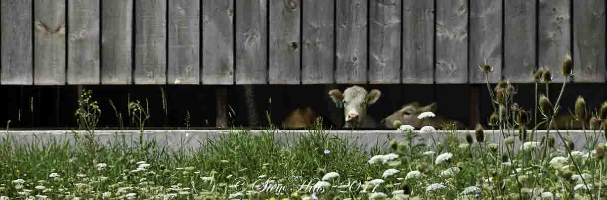
Another concession and you come to the Alpaca Farm.

And across the road is one of two cemeteries you pass.  This is the old New England Cemetery, kitty corner from the old New England Church, now a house.  I actually had someone ask me once why they buried all the people in the centre of the small area.  In fact, they have gathered up the tombstones and placed them together to allow for continuing maintenance, as has been done with many tiny rural cemeteries in southern Ontario.

Just over the hill you drive down into a long bit of swamp, and yes, that's where the first fall colours appear.  This was taken today.

There are at least 4 dead-end sideroads that run to the east off the 7th Line, ending where they bump into the Niagara Escarpment cliffs.  All of them have sections that are forested like this, and virtually no traffic.

Another concession, and you pass the beautiful old Sligo School, one of the few stone one-room schoolhouses I've seen here.  I know someone who went to this school, now a residence.

And a concession beyond that is the only nearby canola field I've found this summer.

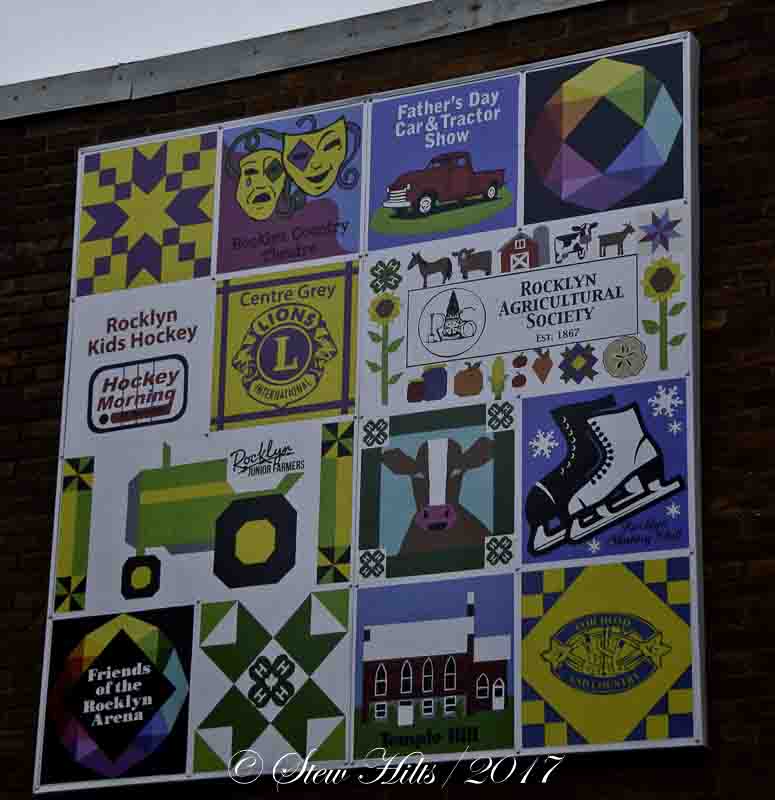
Then it's the village of Rocklyn.  The quilting group there is behind the barn quilt trail here, and they contributed this 'quilt' to the village, highlighting several of the active groups in the village.

This may sound like just a travelogue, but to me it's a matter of being embedded in the landscape, a sense of belonging that grows out of familiarity and comfort with the rural community.  As you get to know the farms, fields and woodlots in all the seasons, and get to know a few of the people who live along the road, you feel anchored in that landscape.  It's always on my mind as I drive back and forth.  The second half of the drive tomorrow.

****

I was shocked today when the sun didn't rise until after 7!  I might even be up early enough to see the sunrise a few times.  The seasons move relentlessly on and the days get shorter and shorter.

Tuesday, August 29, 2017

Seen Around the Valley

I accumulate a number of interesting pictures as I drive around the valley from place to place.  Here are a few I've shot recently.

Close-up of a big leaf out in a shaded corner of our meadow.

A very bright green patch of moss just outside the front door.

Wild Cucumber in bloom at Walters Falls.

A small original log house on a farm I visited.

An old gas pump in front of a friend's garage.   My great-aunt pumped gas from a pump like this.

The Blackbird Pie Company in Heathcote down in the valley.  A great place to buy both fruit and pot pies.

A warning sign for Poison Ivy (those three leaves at the base of the stake), outside the Nancy Historic Site.

And a few great muffins that Mrs. F.G. whipped up.  You can see how good they were by how many are already missing!


Monday, August 28, 2017

The Garden in August

It's hard to believe but the garden is winding down for the season.  The day lilies are almost finished, and a lot of other plants are collapsing, having grown too large with the excess rain this summer.  But we still have some beautiful flowers coming into bloom for one last burst of garden colour.

The combo of Brown-eyed Susans and Purple Coneflowers that form a band around a big rock right in the middle of the yard become one of the bright points in the yard for a few weeks at this time of year.

We've got yet another tall yellow flower, a flower that stands nearly 8 feet tall.  You can judge that beside the fence here, which is about 5 feet high.

I have trouble sorting out our 4 different yellow flowers all in the sunflower family, but I think this is the Cutleaf Coneflower, that typically blooms in late summer, and is very tall.  In our experience it has not spread at all from the three big clumps we have, unlike the other tall Gray-headed Coneflower (which is actually yellow), which spreads like mad by self-seeding.

We've got a tall pale pink Obedient Plant that blooms at this time of year.

And the orange version of the bright red Crocosmia that I shared recently is now in bloom, a truly beautiful little flower.

I love the colours of this Helenium.  Looking from the top it looks mostly yellow, but it's up to 6 feet high, so I often see the blooms from below, in which case they're a striking range from yellow through orange to red.

We have several different brightly coloured Phlox in bloom now.

And the plant Ligularia, that I've incorrectly described in the past as Elephant Ears is now in bloom, a flower that I originally thought was a really great addition to the garden.  I feel differently now because it spreads relentlessly and is very hard to get rid of!

And here's one final bloom of the daylilies.  There won't be many more of these, but we've enjoyed nearly two months of many bright blooms.


Sunday, August 27, 2017

The Nancy

It was a beautiful Sunday and we decided we needed a break.  Picked Wasaga Beach as our destination, and then checking Google Maps remembered the Nancy, a ship from the War of 1812.   It's featured at a Historic Site near the mouth of the Nottawasaga River.

This is the Nancy, a sailing ship built at the (then) British port of Detroit in 1789, primarily for the fur trade.  It would carry trading goods upstream from Fort Erie at the east end of Lake Erie, to Forts St. Joseph and Michilimackinac in upper Lake Huron, then both British fur trade forts.  There the trade goods would be exchanged for the furs brought east down Lake Superior, in these years for the North West Company.  The Hudson's Bay Company shipping went to and from Hudson's Bay.

This is the remaining hull of the Nancy.  It's totally enclosed, so it's hard to get photos without reflections.  When the War of 1812 was declared, the ship was drawn into service for the British navy.  At the Battle of Lake Erie the American navy destroyed all the British ships involved, but the Nancy was away on a trading mission to the north.  It survived as the only remaining British navy ship on the upper Great Lakes.

In this picture I was struck by the ship's ribs, which are flattened on one side, but are just the original shape of the tree trunks that were used.  The American ships headed north to take Fort Michilimackinac but the Battle of Mackinac Island was inconclusive.  The three ships headed down Georgian Bay to try and find the Nancy.

They found it at the mouth of the Nottawasaga Bay, hidden a short distance up the river.  Three American ships with many more men and larger cannons than the Nancy's crew, led the Captain of the Nancy to rig the ship with gunpowder, planning to blow it up rather than surrender it to the Americans.  The ship burned to the waterline.  This is the building housing the remaining hull of the Nancy, and the adjoining museum (which was excellent).  The Nancy lay buried under sand here for over 100 years before it was excavated in the 1920's.  Now it's known as Nancy Island.

The park also had a model of a bateaux, the smaller rowboat known among the natives as the 'White Man's Canoe'.  It was widely used in the fur trade.  The Nancy's crew escaped in boats like this and rowed all the way to Fort Michimilimackinac.  There they surprised two of the American ships and captured them, renaming them 'Surprise' and 'Confiance'.  The British had retaken control of the upper lakes thanks to the crew of the Nancy, undoubtedly a big influence on the future border between our nations.

The small museum was great!  This 'voyageur' picked out a tune on her fiddle for us.  The two young women were able to answer all my questions about the displays, the Nancy, and the War of 1812 in general.  I could go back here with a pen and notebook and spend a whole day.

This visit, short as it was, opened several new doors in my own mind.  First, I learned that the War of 1812 was as much about naval battles and control of the Great Lakes, as it was about the land battles at Niagara, which I have known about for years.  The stories of Laura Second, Queenston Heights, and Lundy's Lane are familiar to many Canadians, but I doubt many know about the Nancy.

It also made me think about the role of the First Nations at the time.  The British got along well with the native bands, thousands of whom fought on the British side.  This of course means that there were many thousands of natives living here long before white settlement arrived.  Key areas in southern Ontario were quite densely settled.

The Toronto Carrying-Place Trail was a native portage trail from Lake Ontario to Georgian Bay via Lake Simcoe.  Adapted for use in the fur trade, it was a native route for thousands of years before that.  Having paddled part of the Voyageur trade route down the French River, and the Bloodvein River in northwest Ontario, I know that these routes had been used by native peoples for thousands of years too.

Canada did not evolve as a nation until 1867, but the centuries before this fascinate me.  I expect you'll hear more of these topics in the future as I pursue these ideas.  A nice Sunday afternoon drive turned into a very interesting lesson in history.