Friday, January 31, 2020

Post-Glacial Lakes and Apples

Did you know that the location of post-glacial lake shorelines along Highway 26 determines where apples are grown around Meaford today?  It's an interesting story.

You've heard me top about apple growing around here before.  The Vail Orchard is the closest on-farm apple outlet that we stop at, but there are several others available.  We get to know what apple varieties we like best, and we always buy them locally.

This map shows the landscape along Highway 26 from here to Owen Sound, a 'physiography' map.  As you can see, there's a big yellow crescent around the town of Meaford.  This is the old lake-bottom of post-glacial Lake Algonquin, old sand and gravel deposits that provide the ideal well-drained soil for apple trees.  The shoreline 11,000 years ago followed that bright red line which are old beach deposits.  The Vail Orchard is located right where you see that number 26 in a small circle.

This is the view from the highest point looking back at that flat lake-bottom extending west of Meaford.  The Vail Orchard is down there on the right in the distance.

This provides excellent flat, well-drained soil for the apple orchards, here some of the high-density trees planted in recent years.

If you follow the map to the east you find the very same thing around Thornbury, the other nearby apple growing area.  These two yellow patches of soil make Grey County the highest apple producing region in Ontario.

This is the unique Red Prince orchard south of Thornbury, the first high-density orchard planted in the region.  I'm eating Red Price apples these days; they're a late apple which are excellent over the winter and even into spring and summer. 

That high density planting is spreading rapidly here, as shown in this very blurry picture of a brand new orchard across the road where a traditional orchard was torn out and replaced with this.

The other factor is microclimate.  The deep cold waters of Georgian Bay only warm up slowly, so apple trees normally blossom two weeks later here in the spring.  This reduces the risk of them being caught in a late frost.  In the fall the water is relatively warm which delays frost at that end of the season.

So apples are the best example of a relationship between soils, climate and land use along this road.  Hope you learned something interesting.


Thursday, January 30, 2020

More Barns

I've been moving from best to worst in this tour of the Highway 26 barns, (see yesterday's post)so today is the bottom half of this spectrum.  In the case of farms that are still active I find myself wondering about what sort of operation the farmer runs.  But in the case of these barns I find myself wondering how did it ever get to this point!

The first group of four are all barns that are still standing, but where I can see no evidence of active farming, unless they're using the barns for storing hay.  Certainly some of the accompanying fields are still being hayed.  I like the picture that the last one makes, nestled in the trees.

This old drive shed looks stable for the moment, but the barn beside it is now gone, just a collapsed pile of rubble.

One of the few cases where I actually have a before and after picture, this blew down in a windstorm last spring.

This barn, just down the road from the one above, was completely and carefully demolished, along with the farmhouse, in one week last year.

I'm thinking that these two may be the next to go; they're looking pretty unstable.

This barn accompanies the old farmhouse on the edge of Owen Sound, right beside the big box stores.  All boarded up and for sale, but no telling how long it might sit here unused.

Finally there are barns that are now missing,just the old concrete shell of the silo remaining to mark the site of a former farm home.  So we've got the complete spectrum of farms and barns along this road, from well-maintained and active to fallen down or just about to fall down!  An interesting story in the economics of farming these days.

Just in case you think this is typical of this part of southern Ontario, here's a nice farm not too far away in a different direction and on better soil.  And if you went further, down into Huron County, you';d find very large modern farms that look dramatically different from any of these.


Wednesday, January 29, 2020

Barns

The most common features that I notice along this stretch of highway are the barns, in all different condition - from missing entirely to quite modern.  The barns tell a story of economic change and land use as farmers adapt over time to changing circumstances.  The soil here is variable to say the least, and in many cases the farms are very marginal, so agriculture is going downhill and barns continue to disappear.

I think this is the most modern barn, built recently, I suspect to take advantage of government subsidies for solar power - a whole roof of solar panels!  But it never seems to be used much, although there have been a few horses in the field recently.

This is the nicest of the older barns, on this farm well-maintained with some new outbuildings.  One of the few barns with a fresh coat of paint!

This is a sheep farm, and we see them grazing in the pasture all summer long.

Another farm sitting on the side of a long drumlin.  No new coat of paint here, but it is well maintained.  This is a cattle farm; we seem them all summer long too.

And another cattle farm.  In this case the cattle are allowed outdoors, at least in the milder winter  weather we've been having this year.  They're all clustered around hay bales put out for them to munch on.

Haven't seen any evidence of cattle on these two farms, but they certainly had a good crop of hay last summer. 

There are no dairy farms here; the soil is not good enough to support the crops and pasture that would be needed.  At the other end of the spectrum, beef cattle take much less time commitment from the farmer.  I suspect that on all of the cattle farms here the farmers have some sort of off-farm job and the beef cattle are more like a money-draining hobby! 

As well a number of farms where there is still a barn standing are home to non-farm rural residents who just prefer to live in the country.  And some may be home to retired farmers who have quit farming, but never moved off the farm.  Often these are sad cases where maintenance goes downhill until the farmer reluctantly moves to town.  Tomorrow the rest of the spectrum down to the missing barns.


Tuesday, January 28, 2020

Highway 26

I've been trying to pull together a description of Highway 26, the road we travel from here to Owen Sound for physio once or twice a week. We must have traveled it 100 times or more over the past 14 months.  Once I got over the initial boredom, it's really quite an interesting drive, with changes in the landscape, barns in all sorts of repair or disrepair, forests and farm fields, and rockcuts of the Niagara Escarpment.

I'm not pretending that you'll be interested in the details, but I am.  I've always had an interest in a bit of everything.  In my teaching career, I tried to help environmental science students learn to put it all together, starting with geology, through soils and vegetation, hydrology and meteorology, to present day land use and management.  So as I've driven this road I've been asking myself about the rocks we pass, the little streams, the land use.  Why are there farms in some spots and forests in others?  How is it all related?

I apologize in advance for the pictures.  Some are taken on dull days; they're just taken to document things in my own mind.  And this is very much a first draft as I seek pictures to tell the story.  Doing this will help me recognize what pictures I need to take in the future.

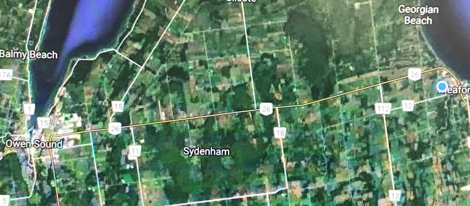
This satellite view shows Highway 26 running from Meaford on the right to Owen sound on the left. As you can see there are both farm fields and forests along the way. And sideroada run north and south. Several of those sideroads turn out to be short dead ends because of a large swamp. Come with me as we drive the 25 kilometres to Owen Sound.

The first stretch of road is relatively flat; this is where we find the apple orchards.  More on why they are here and not elsewhere tomorrow.

Soon we're driving up a long hill that is actually the old shoreline of post-glacial Lake Algonquin, which extended a long distance up the Bighead River valley.

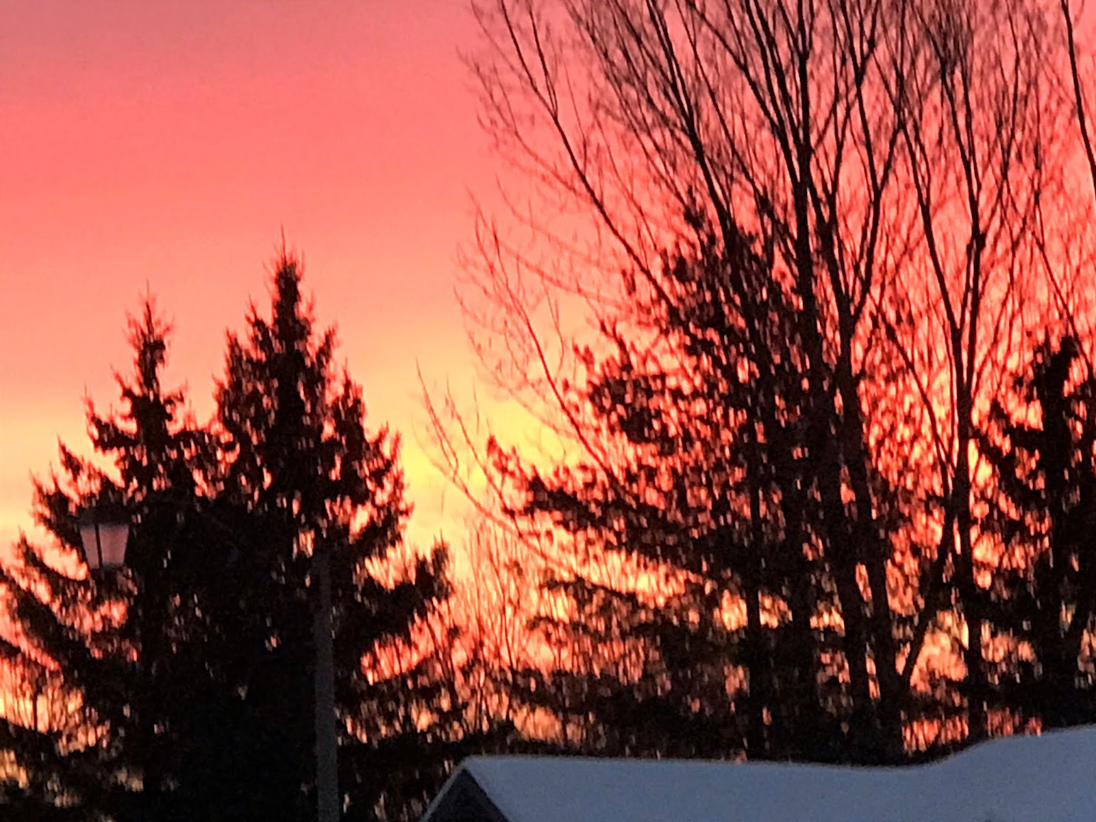
If we were to stop and turn around at the crest of that hill (at a corner appropriately named 'Bayview'), we'd get this view toward Meaford and Georgian Bay.  The bay is certainly not frozen like this this year!

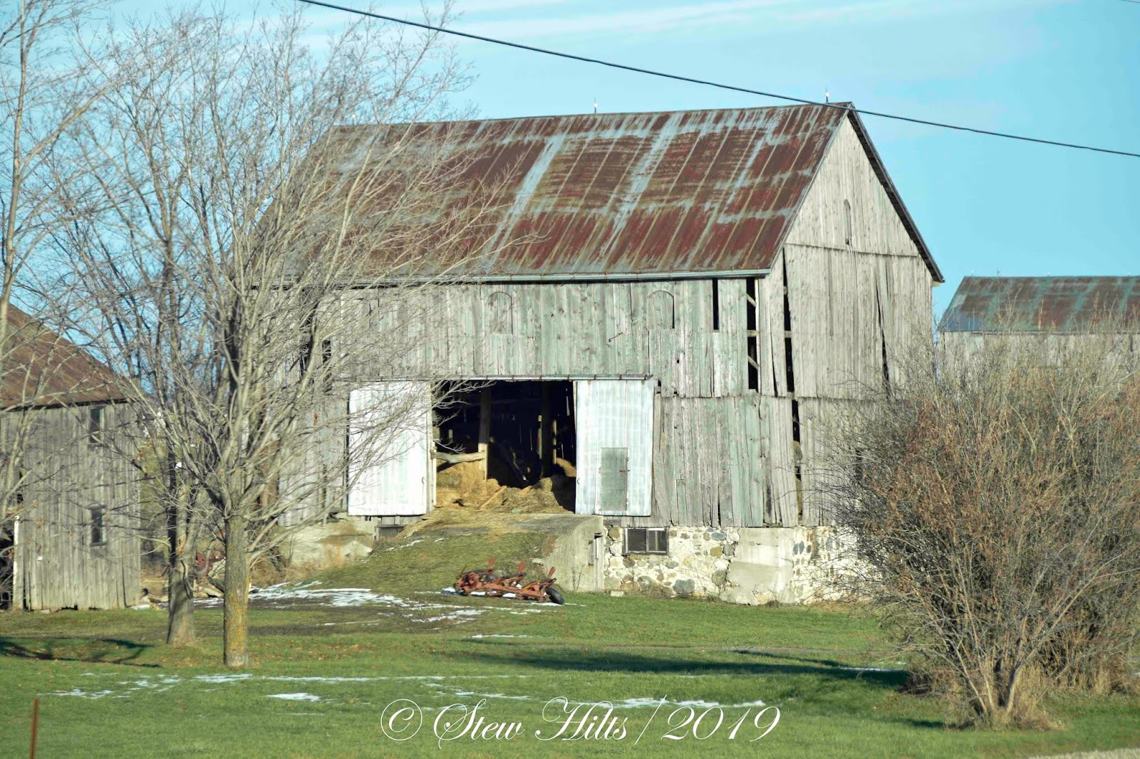
The next stretch takes you up and down over several hills that are actually glacial drumlins.  This old barn sits on the side of one of those drumlins.  Don't know if it's actually used, but it does stand on an active farm so it's probably used for storage if nothing else.

Other farms are not so active anymore, though a couple have left the evidence of an old homestead, barn foundation and silo behind.

Then we enter the first rock cut at Woodford, rising up to drive on top of the escarpment for awhile.  The Bruce Trail crosses here, with interesting properties on both sides of the road.

Now that we're on slightly higher land we notice that there is more likely to be a dusting of snow here, when there might not be back in Meaford.  There's a consistent microclimatic difference here.

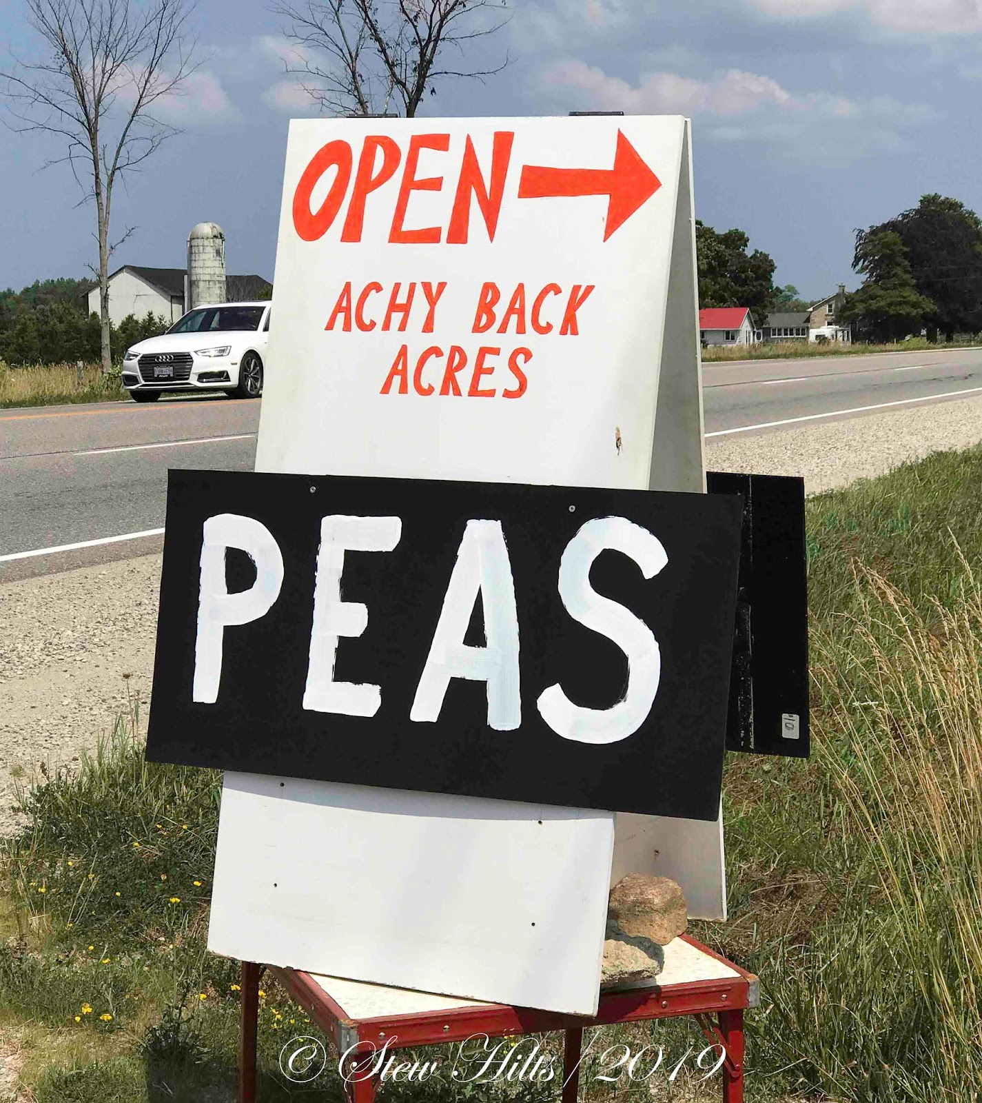
After the forested stretch we pass 3 or 4 active farms, including Achy Back Acres where we stop to buy veggies in the summer.

Then we're passing back through a rockcut and down into a broad valley.  It took awhile looking at maps, but I figured out that this is the valley of Keefer Creek, which has a nice waterfall downstream.

Shortly after that we're back up on a relatively flat stretch for a distance.  This is where Owen Sound's Billy Bishop Airport is located.  Bishop was a native of Owen Sound.

After that you're driving down over the escarpment once again as you approach Owen Sound in the distance.  The Bruce Trail joins the road again here and follows the road for a distance.

On the outskirts of the big box stores as you arrive in town there is a last farm, now boarded up and awaiting demolition.  At this point my interest in the landsape ends!  Over the next few days I hope to share with you some of the thing you see along this drive, including some of the relationships that interest me.


Sunday, January 26, 2020

Sunrise

Another nice sunrise the other day to share with you.

Hope you're enjoying the weekend!