Sunday, February 28, 2021

The Royal Proclamation of 1763 - Promise and Threat

I started this as an attempt to show the racism toward Canada's native peoples as well as our black population, but there are so many ideas and snippets of history roaming around in my head it's all a big jumble.  So this is my first attempt to sort it out.  I'll be interested in your comments.  And if it's just too much information for you, I won't know if you just skip it!

The Royal Proclamation of 1763 was issued by King George III after the first Treaty of Paris in 1763 that ended the French Indian War, the North American theatre of the Seven Years War between Britain and France.  If you're like me until a few weeks ago, you've never heard of it.  Yet it set up the foundation for the betrayal of native peoples on the continent ever since.

The French and Indian War was far more significant for Canada than for the U.S., though it started when a young 22-year old George Washington, then a commander in the British army, led a force to capture Fort Duquesne at the junction of the Ohio and Allegheny Rivers, where modern Pittsburgh stands.  

On the Canadian side, British forces from Massachsets under General Wolfe captured Quebec City (above) and thereby took over New France.  Montreal fell the following year and a vast chunk of territory north and west of the 13 American colonies became British North America.  Along the way the British kicked the Acadians out of Nova Scotia and some of those ended up in New Orleans, bringing their 'Cajun' culture with them.

The French had had far more Indian allies than the British and after the war some of those feared loss of their lands to the British, a fear that spurred Pontiac's Rebellion during the summer of 1763.  In response King George III issued the Royal Proclamation to try and assure the natives of British protection and to draw a line between the natives and increasingly hostile would-be American settlers.  In it the natives were promised all the lands west of the Appalachians, all the way to the Mississippi, a promise that would quickly be impossible to keep of course.

The west portion of the Mississippi watershed, west of the river itself, that the British theoretically gained from the French, was given to Spain to compensate them for the loss of Florida.  This is the land that would later become the Louisiana Purchase.  The map of North America was totally redrawn!

A bigger impact of the war in the long term was to massively increase both the French and British debt.  In France this was a grievance leading to the French Revolution, and in the Thirteen Colonies the tax burden to pay it off contributed to the American Revolution.  The Boston Tea Party was the most obvious protest of Americans against those British taxes.

But I'm getting off-track.  To get back to the Royal Proclamation, the actual wording is important.  As quoted in the Canadian Encyclopedia:

".... whereas it is just and reasonable, and essential to our Interest and the Security of our Colonies, that the several Nations or Tribes of Indians, with whom We are connected, and who live under our Protection, should not be molested or disturbed in the Possession of such Parts of Our Dominions and Territories as, not having been ceded to, or purchased by Us, are reserved to them,..."

On the American side of the border of course this went completely out the window 20 years later when the second Treaty of Paris ended the American Revolution.  The west was thrown open to settlers and a policy of Indian Removal was implemented, moving the natives further west to allow for settlement.  Specific forced removals remembered as the Cherokee Trail of Tears and the Potawatomi Trail of Death illustrate this policy.  

The latter is of particular interest here in Ontario because the Potawatomi were members of the Council of Three Fires with the Ojibwe, who now live near here.  Some members of the Potawatomi were able to escape the march west from Indiana and joined the Ojibwe here, descendants of whom live on reserves west of Owen Sound.

On the Canadian side of the border the royal Proclamation was both a promise and a threat.  On the positive side it recognized that the native tribes or 'nations' (remember that word, it will be important later) had possession of their lands and associated rights like hunting and fishing.  It forced the British crown to negotiate treaties with each nation before settlement could occur.  This meant that settlers would only get their land from the government, not by simply displacing natives.

On the threat side, though perhaps unrecognized at the time, it set up a process through which the British crown could acquire all that native land for settlement.  The natives interpreted those treaties as promising to 'share' their land, like the peace and friendship treaties they had been negotiating between tribes for hundreds of years.  The British saw the treaties as purchasing the native lands, to be used as the purchaser, the crown, deemed appropriate.  Eventually those treaties would push Canada's indigenous peoples onto 'reserves', relatively tiny parcels of land where they were left to struggle for survival.

After Confederation and Sir John A. MacDonald's promise to build a railway to the Pacific, there was an enormous push to sign treaties across the prairies.  Settlers were pushing west in Canada and south of the 49th parallel Americans were pushing across the continent.  Eleven numbered treaties were signed (below) that pushed native tribes all across the prairies onto small reserves.  


The Royal Canadian Mounted Police were introduced, in part to ensure the clearance of the prairies for settlement and the railroad.  They used a variety of threats and policies stemming from these treaties to force natives onto reserves in these areas.

But I think this has got too long and information dense already, so I will return tomorrow.


Saturday, February 27, 2021

Owen Sound's Black History Memorial

 As I've shared before there's an Emancipation Festival in Owen Sound that's been going on for 158 years!  It happens on Aug. 1st, celebrating Emancipation Day, originally the abolishing of slavery in the British Empire on Aug. 1, 1834.  The success of the annual festival led to establishing a Black History Cairn that sits in Harrison Park beside the Sydenham River.

The cairn is symbolic in several ways.  The church windows model those of the old 'Little Zion' church, the first black church in Owen Sound.  The quilt patterns on several tiles on the ground represent the Underground Railway, where quilts were used as secret messages leading slaves north.  You can see the river in the background.

As you can see, some rocks have tiny plaques attached.  These come from a number of U.S. states, reflecting the previous homelands of slaves.

The cairn is approached from the entrance to Harrison Park along the Freedom Trail, a beautiful path through the woods.  Naturally the BLM protest in Owen Sound last summer was held here.

Last year the festival was virtual of course, and we happened to be there on the day they were filming the role of the Town Crier with his scroll.  And he did a good job of 'crying the welcome'!

The Underground Railroad existed primarily during the 28 year gap between the year slaves in Canada became free, and the day when American slaves were freed by Abraham Lincoln on Apr. 1, 1862, although American slavery didn't really end until the Civil War was over in 1865.  Owen Sound's picnic began in 1862 however.  

The Canadian Emancipation Day is celebrated on Aug. 1, the date slavery was abolished here in 1834, but American celebrations are more varied.  From my limited reading 'Emancipation Day' is celebrated in April mostly in Washington D.C., but there's an effort now to get 'Juneteenth' recognized as the national celebration.  It was on June 19th, 1865 that the Union General Granger finally reached Texas, the last state to hear, to proclaim that slaves were now free.  All but 3 U.S. sates now recognize Juneteenth as an official ceremonial or state holiday.


Friday, February 26, 2021

Black History Month

February is Black History Month, and our national broadcaster, CBC, has been full of articles about interesting and famous Black Canadians.  I sometimes get frustrated that it's easier to celebrate those public individuals who have established a reputation than it is to tackle the difficult issues of systemic racism, but still, these people deserve more recognition.

Here are a few of the people I've read about recently:

Emery Barnes was a gifted athlete from Oregon who almost made it into the NFL (and into the Olympics as a high jumper).  He moved to B.C. and played 3 years for the BC Lions of the Canadian Football League, while also getting a degree from UBC.  He was elected to the provincial Legislature in 1972, and served 24 years through 5 elections.  He was the first black speaker of the house in a Canadian province.

Carrie Best became a civil rights activist in Nova Scotia after experiencing racism growing up.  After being arrested and forcibly removed from the 'whites only' section of the Roseland Theatre in 1941 she established The Clarion newspaper and began her campaign against racism.  It was one of the first newspapers in Nova Scotia owned and published by Blacks.


I wanted to pull the $10 bill out of my wallet and share the picture of Viola Desmond (below), but I thought I might get arrested for publishing an image of money, so Carrie Best's picture on a Canadian stamp seemed safer.

Viola Desmond followed Carrie into a theatre in Nova Scotia in 1946.  She too was arrested and charged with trespassing in the 'whites only' seats, so sued the theatre.  The Supreme Court ruled against her, but she was eventually pardoned in 2010, 45 years after her death.  She is the one whose picture is currently on our $10.00 bill.

Albert Jax was Toronto's first black postal carrier, also recently featured on a Canadian postage stamp.

Michaelle Jean was the 27th Canadian Governor General, serving from 2005-2010.  She came to Canada as a refugee from Haiti in 1968, and worked for years as a journalist and in charity, mostly directed at assisting youth living in poverty.  Her term as Governor-General was well received; she has received numerous honours and awards including 17 honourary degrees.  

Harry Jerome was one of the world's fastest men through 3 Olympic games. Though he never won the gold, he set the world record for the 100 yard dash 3 times, the last time at 9.0 seconds!  Born in Saskatchewan he had actually been a gifted athlete in several sports.  Harry was named the B.C. Athlete of the Century and a statue was erected in Stanley Park in Vancouver.

Ira Johnson was an Oakville man who was threatened by the Ku Klux Klan (yes, here in Ontario) when he and a white woman planned to marry in 1930.  A cross was burned in the street by 75 members of the KKK who then kidnapped the woman and further threatened Johnson personally.  However public opinion quickly turned against the Klan, who included several prominent businessmen, and the pair ended up getting married a month later.

Kay Livingstone worked as a radio host and actress starting in the late 1940s.  She helped establish the Canadian Negro Women's Association (CANEWA), a group which started the famous Toronto Caribana Festival.  These efforts led eventually to the Congress of Black Women in Canada.

Elijah McCoy was born in 1844 to fugitive slave parents who had come to Canada via the Underground Railroad.  He studied as a mechanical engineer in Scotland and returned to the family, then in Michigan.  McCoy became an inventor whose practical inventions focused on improved lubrication systems for railways.  Because his system was seen as better than others, it was sometimes referred to as "the real McCoy".

Annamie Paul is a lawyer and politician who was elected as the Green Party leader last October, the first black Canadian to lead a federal party in Canada.  She was born in Toronto in 1972 and has been active in politics all her life.  

Willie O'Ree was the first black hockey player to make it to the NHL, breaking that colour barrier and therefore referred to as 'the Jackie Robinson of ice hockey'  He only played one season and a few games in another with the Boston Bruins, but he won two scoring titles in the Western Hockey League.   He received numerous awards after retiring for his lasting impact on the game of hockey.

Lincoln Alexander is the one among all these famous black Canadians who I knew personally.  Alexander was the first black Canadian elected to Parliament, the first to be a federal Cabinet member, and the first Lieutenant-Governor, here in Ontario.  


I got to know him when he served as the Chancellor at the University of Guelph for 16 years where I taught.  For three of those years I was on the University's Board of Governors where I interacted with him personally, and I also sat among the 'dignitaries' on the platform (he was one, I certainly wasn't!) at convocation.  It was there I heard him say some different kind words to every single student who crossed the platform to graduate.  He was simply one of the most humble, dignified, thoughtful men I have known.


Wednesday, February 24, 2021

The Erebus and Terror

In August of 2007 a titanium Russian flag was planted at the North Pole in the bottom of the Arctic Ocean by Russian scientists in a submersible.  In response politicians in Ottawa started wondering what Canada could do to reinforce its own claim to Arctic waterways.  Someone, perhaps Prime Minister Harper himself, got the bright idea of finding the Erebus and Terror, Sir John Franklin's still missing ships.  

In my opinion it was a great idea and today makes a great story, the one that I find the most intriguing in the Arctic today 

The two ships were named National Historic Sites in 1997, a designation that gave Parks Canada a role in any future decisions about the ships, even though their locations were still unknown.  Under maritime law, the ships still belonged to Great Britain, though after they were found ownership was transferred to Canada.  

During the past decade Parks Canada led a team of underwater archeologists with support from several different agencies and organizations to survey and eventually find the two ships, solving perhaps the greatest Arctic mystery of our time.  The search took several years given the very narrow window in ice cover during late August and early September when such work could be undertaken.

Fanciful and realistic illustrations of the Erebus and Terror, the ice-strengthened 'bomb ships', chosen for Franklin's expedition to withstand the ice.  And they have largely withstood any crushing impact, for 173 years, even underwater.  On the wrecks they found only the stern of the Erebus has been slightly damaged.

As I wrote in an earlier post, there have been numerous searches for artifacts and evidence even well into the 20th century.  This pile of empty tin cans arranged in the shape of a cross, the cans weighted down with small stones, was found on Beechey Island where Franklin spent the first winter.

This is the only actual note Franklin or his men left, found by McLintock's men in a rock cairn on King William Island in 1859.  The note is just the scribbled writing around the sides.  Part describes the progress as expected over the first two years, until the ships were frozen in for the winter of 1846.  The second part was added in the summer of 1847 after Franklin himself had died, and the remaining men were setting out to walk south.

This is a fascinating map which shows the location of artifacts found, and the modern search areas for the two ships.  It hides decades of effort that went into many expeditions which found those artifacts, and 7 years of searching by a team of several ships from 2010 to 2016.  The yellow shows areas searched in previous years, and the red the main search area in 2014 when Erebus was found.  The red lines are ships going back and forth seasonally to Cambridge Bay, out of sight on the left.  King William Island is about 150 km. from the northwest tip to the southeast.

The search proceeded by towing a submersible 'Underwater Archeological Vehicle' (UAV) back and forth through the water, 'mowing the lawn' in Parks Canada's words, gathering images of the sea bottom as well as the soundings needed for 21st century charts.  The images of the ships showed up quite quickly once they were located.  The Investigator, McClure's ship far off in Misery Bay on Banks Island, was found during a short search in 2010, while Erebus was found in 2014 and Terror in 2016.  It was actually a helicopter pilot's observation of a large metal artifact on the ground that provided the vital locational clue to the Erebus wreck's location.

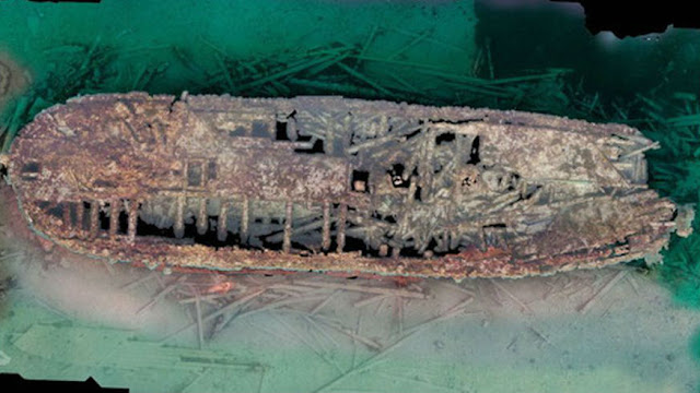
This is the Erebus, the ship found first.  Remember the searchers were working in a window of only 2-3 weeks in late August/early September when the ice was clear enough to do this.  You can see that this wreck is damaged a little, and part of the stern is missing.  Still the Parks Canada archeologists were thrilled to find the ship in such intact condition.

The finding of the Terror proceeded a little differently.  On the way to continuing the search, an Inuit member of the crew on one ship mentioned having seen a possible ship's mast sticking out of the water in Terror Bay on the south side of King William Island several years earlier.  The ship took a short detour for a quick look, and there it was!  (They were later criticized for taking a detour without permission).  And the Terror was in remarkably good condition, looking completely intact.  It turned out that the Terror's mast may have been sticking out if the water in Terror Bay for 150 years+ and nobody noticed!

In the four years since, Parks Canada has been diving on both ships, bringing to light artifacts that may help tell the history of the doomed expedition.  With such a short open water window, they have extended the season by cutting an opening in the ice for the divers.  Below an archeologist is using a hot water drill to cut this opening in April 2017.

The sites are not yet open to the public, and may never be.  Inuit guardians have been hired from the closest town of Gjoa Haven on the southeast side of the island (see map above) to watch over the two wrecks.  The town is hopeful that an interpretive centre/museum will be built in the future, but of course already cruise ships are starting to visit and local interpreters give visitors some insight into the search and the ships, including the critical role that Inuit oral history played in the whole story.

The is the ship's bell from the Erebus, a key item that helped in identifying the ship (finding it wasn't enough, they still had to be sure it was the correct ship!).  All the ships are covered with a growth of various marine plants and animals that needs to be carefully cleaned off.

And this is the ship's wheel on the Terror.  On this ship searchers have found dishes and bottles still sitting on shelves, and cabins still arranged as if they were ready for their occupants.  Archeological investigation always goes slowly of course as the archeologists carefully document exactly where every artifact is found.  Most interior study of the ships to date has only been by underwater cameras

Some articles I have read express a hope that a ship's journal may be found, completely preserved in the cold Arctic waters.  That could tell a more complete story of the expedition's sad ending.  In fact, the condition and location of the Terror already implies an intriguing further mystery, as investigators are now suggesting that the men may have gone back to the Terror where it had originally been abandoned and re-sailed it, anchoring in a sheltered bay for protection where it settled gently on the bottom.

In any case, this is a story we certainly haven't heard the ending of.  Britain has now gifted the two ships to Canada and Parks Canada is managing the future of this fascinating National Historic Site.

'Qauijimajatuqangit' 

Once I started reading Ice Ghosts I quickly realized how much the search for Franklinès ships (and Franklin's original expedition itself) had neglected Qauijimajatuqangit or Inuit traditional knowledge.  Inuit today, based on several generations of stories from their elders, knew of ancestors who had actually seen the two ships, in the final locations where they went down.  There are even stories of ancestors who had talked to some of Franklin's surviving men.  But we still largely ignored their knowledge even during the recent search for the ships.  

During Franklin's day and the rescue missions which followed him, the prejudice against the Inuit was much more explicit.  As Watson writes, "One truth is eternal: Royal Navy prejudice toward indigenous people helped doom the Franklin Expedition, and the arrogant disregard for Inuit knowledge prolonged efforts to find out what happened to Sir John Franklin and the men he led to their deaths".    

In spite of that it was Inuit oral history that provided most of the final clues to finding the ships.  Louie Kamookak was an Inuit historian living in Gjoa Haven who provided much of the knowledge, after interviewing many elders about their memories.  Hopefully we've learned something from this!


Tuesday, February 23, 2021

Tallurutiup Imanga, Auyuittuq, Sirmilik, Qausuittuq, Quttinirpaaq

Here we are, finally back to my last two Arctic posts, these on the big natural parks and on the finding of the Franklin shipwrecks.    Hope you enjoy them.

Tallurutiup Imanga (known by whites as Lancaster Sound) is by far the largest protected area in Canada, and one of the most significant ecosystems in the world.  It's a National Marine Conservation Area, the equivalent of a national park but in the marine environment.  This is a land of water, ice, and marine mammals, traditional hunting and fishing area of the Inuit for 4000 years or more.  Icebergs float by and whales swim past.

The food web here starts with microscopic marine organisms that are eaten by larger creatures and then fish.  The fish feed the seals and whales, and the seals and fish feed the Polar Bears and the Inuit.  Narwhals are just one of the iconic wildlife species here.  There are also Beluga and Bowhead Whales, Walrus, and those Polar Bears.  It's one of the most significant and least disturbed natural ecosystems in the world.  

The proposal to conserve this area has been developing for some years, with proposals from both Parks Canada and the regional Inuit association.  Shell Oil's donation of a group of offshore oil leases in nearby Baffin Bay was an important spur to final approval.  The final area, as you see on the map below, is enormous (it dwarfs any other protected area in Canada) and includes not only all of Lancaster Sound west as far as Resolute, but Admiralty Inlet, Eclipse Sound and the western side of Baffin Bay.  It wraps around most of Sirmilik National Park.

This was very much a joint effort of both the Inuit who wanted their homeland protected and conservation organizations like the World Wildlife Fund, as well as Parks Canada.  Under the terms of the Nunavut Land Claims Agreement that was built into the establishment of Nunavut as a separate Arctic region, the Inuit will retain all their traditional hunting and fishing rights, and be co-managers of the area.  They have been an integral part of all these Arctic ecosystems for 4500 years.

A key critical feature of this area is the 'polynyas', open areas of water at the ice floe edge.  This is a very tiny one, but seals, walrus, whales and polar bears as well as these surfacing Belugas all feed at the floe edge, so this is the place to see them.  And they all have to come up to breath eventually!  They're not aquatic animals, they're marine animals!

Beyond that spectacular natural area there are four other national parks on the Arctic islands.  Of the four national parks located on the Arctic islands, Quttinirpaaq on the north end of Ellesmere Island is by far the largest and most northerly.  Of the other three Sirmilik is the one we'll look at first.

Sirmilik National Park, or "Place of the Glaciers", is almost surrounded by Tallurutiup Imanga.  It includes all of Bylot Island and large areas on Baffin Island on both sides of Pond Inlet.  Bylot is known particularly for its millions of nesting seabirds.

Among Arctic parks, Sirmilik is relatively easy to access (after you've paid to get there), so day visitors from cruises docking in Pond Inlet can go hiking on the glaciers and among the hoodoos or take longer excursions out to the floe edge.  The combination of spectacular scenery and the wildlife make it unique among the Arctic national parks.  Of course it also features Inuit cultural sites and the history of Northwest Passage exploration.  As with all the Arctic national parks, registration both upon entering and leaving the park is required; rescue would be expensive!

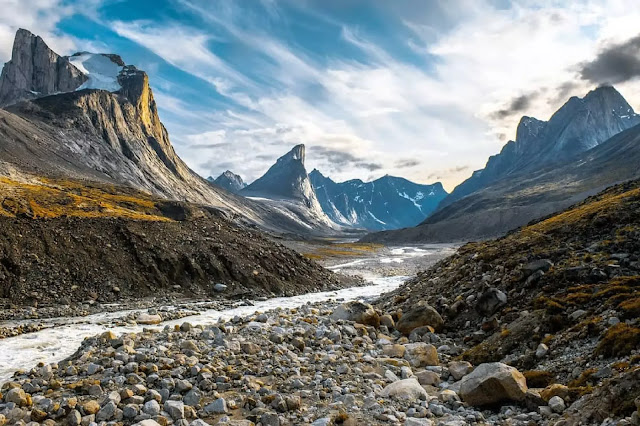
Auyuittuq National Park or "Land that Never Melts", is known for its incredible mountain scenery.  It sits on the south end of Baffin Island, encompassing the Penny Ice Cap, in between Pangnirtung and Qikiqtarjuac.  The popular access route takes you on a 97 km hike through Akshayuk pass, passing Mount Thor with its incredible vertical cliff.

Because of the mountains this is the Arctic's most popular rock climbing destination (for experienced climbers only!).  Wildlife is relatively scarce so hiking is the preferred activity.  And it's an awesome destination you won't forget!

Qausuittuq National Park. or "Place Where the Sun Doesn't Shine", is a group of polar desert islands in a frozen sea providing habitat for species such as Muskoxen and Arctic Wolf.  With the adjoining protected area of Polar Bear Pass it conserves critical wetland and marine habitats that the Inuit of Resolute have relied on since they were unceremoniously resettled there in the 1950s.

The other iconic wildlife species of the park is the endangered Peary Caribou, a small caribou species that is barely hanging on in this part of the Arctic.  The park contains important calving grounds and winter habitat.  

Though the terrestrial environment is harsh, there is rich marine life and a large bird population here.  Both Ringed Seals and Bearded Seals are plentiful, along with Narwhals, Bowhead Whales and Walrus.  As the name of Polar Bear Pass to the south reflects, Polar bears are regularly seen.

Visiting the park is a challenge, though visitors are now welcomed.  As the park was only opened in 2017, there are no facilities or trails yet. You'll be dependent on a chartered flight from Resolute to get here and the only real activity is hiking.

Quttinirpaaq National Park, or "Top of the World", is the second most northerly park in the world, after one in Greenland.  It's a land of ice caps, glaciers and wild rivers on the north tip of Ellesmere Island.  And it's very remote.  Here it's an 800 km. chartered flight to get you here, at a cost of $60,000.00!  Unless you're very well off, you'll have to go in a group!

Quttinirpaaq has similar wildlife species as Qausuittuq, but fewer of them.  The area has never been an important Inuit hunting area.  But Parks Canada does have 3 gravel air strips and ranger stations and there are two hiking routes.  The park was established in 2000.  

Let's just visit the Polar Bear Pass National Wildlife Area before we finish.  This is a large low valley crossing Bathurst Island (named after the British Secretary of War and the Colonies in 1820) featuring an enormous important wetland.  It's home to numerous species of migratory birds, supported by a dense population of insects in the summer months.  Polar Bears also pass through the area heading southwest to feed on seals and walrus on Graham Moore Bay.

A small one-building research station was established here in 1968, long before the protected area was established, and is available for researchers to stay in while conducting field research.  Managed by the Canadian Museum of Nature for many years, this field station is responsible for much of our detailed scientific knowledge of Arctic ecology
.
Tomorrow, the story of the final finding of Franklin's two shipwrecks.  We'll leave the Polar Bear below lounging on the cool ice!

'Qauijimajatuqangit'

I was particularly impressed in preparing this post with the extent to which Qauijimajatuqangit (Inuit traditional knowledge or 'IQ') has been put front and centre.  It's taken us over 400 years, but we're finally learning to respect indigenous oral history as equal to white written history, at least in the Arctic.  This is written right into the establishment of Nunavut, and into Parks Canada's policies.  

If we had done so 165 years ago it might have saved Franklin's men.  We do need to learn this in the rest of North America though!  Here traditional Inuit uses of the land and traditional Inuit knowledge of the wildlife is built right into park management, and Inuit are hired for most park warden positions.  It's notable that there are really no english names for these parks in use, just the Inuit ones.


Monday, February 22, 2021

William, our Hero


William was born Feb. 22, 1977; it seems like yesterday.

He gave his life on May 22, 2015, fighting a forest fire near Cold Lake in northern Alberta.

He followed his dream and found it.

You can read more about him under the tab above.

Saturday, February 20, 2021

Microgreens Harvest


Mrs. F.G. successfully harvested the first crop from her microgreens, planted only 12 days ago.  I shared the first flush of growth with you a week ago tomorrow.  Now we're adding Radish, Beans or Mustard microgreen 'confetti' to our salads.

Here we are, beans, radish and mustard after 10 days growth.

The radishes grew like wildfire!  They taste more like radishes than the enormous but tasteless 'real' radishes we're buying in the store these days!

The beans look good too, and actually taste like beans.

The mustard grew a little more slowly, but it still adds a nice taste.

This is the radish harvest.  You just shave them off with scissors.

And here they are sprinkled over my simple Arugula salad, giving a nice slightly spicy taste to it.

A quiet day here, just working away.  Surprised at how quickly U.S. politics has become suddenly peaceful.  But still very concerned about Texas.  It says a lot about deregulation of the power industry, and does suggest that a few rules for them to meet might be appropriate.  But none of that helps the freezing families!


Friday, February 19, 2021

Waterfalls Presentation! I'm a (Very Minor) YouTube Star!

My presentation on waterfalls in this area for the Thornbury Library went live last Thursday evening, and it worked fine.  It's now up on YouTube so you can watch this scintillating half hour talk if you wish at this link: https://www.youtube.com/watch?v=xkDwlWSdWsY

It's actually risen to over 500 views (in less than a week) which makes it the library's most popular video, and this library has produced a lot of them!  You can also search for it at the 'Blue Mountains Public Library' on YouTube,  search for 'Waterfalls of the Beaver Valley'.


This isn't a secret waterfalls, but it's one you may not have seen yet.  It's half-way through the new Stew Hilts Side Trail Loop.  The walk as far as the falls and out again makes a great winter snowshoe.


Secret Waterfalls - as a way of grabbing your attention, here are two of the 'secret' waterfalls I talk about.


Did you know that you can see two 'secret' waterfalls in the Beaver Valley?  They're 'secret' in the sense that they don't flow all the time.  In the tiny stream above each falls there are sinkholes, and most of the year the water in the creek just drains down through the sinkhole, leaving the waterfall totally dry.  But at least in the high water of early spring there's too much water for the sinkholes, so there's suddenly a waterfall. 


It might be just for a few days, or for several weeks depending on the rate at which the snow melts.  These falls may also emerge into life after a very heavy rainstorm too, but I've never been there to see that.


The first, a falls I've seen described as Minniehill Falls, is just west of the 7th Line on the Bruce Trail, on GSCA property, approximately at km. 111.6.   At dry times of the year you might not even recognize the rocky stream bed as you step across the limestone, but otherwise you may have to leap a small creek.  The falls plunges 20 feet just to your right.  The best view is by going past the creek and looking back.


Parking here is tricky, right at the crest of the large hill down the escarpment, but it is possible to pull a vehicle totally off the roadway on the east side just where the trail crosses.


The second 'secret' waterfall is the Woodford Creek Falls, at approximately km. 42.8 of the Sydenham Trail Section, just outside the village of Woodford.  As the Bruce Trail Guide notes, this waterfalls 'thunders over the edge for about one week of the year'.  The rest of the year it disappears into the rock above, and emerges as a spring below the slope.  If you approach from the west the trail is at the top of the slope.  Over the dry creek it drops down to the level of the spring before heading east.  


Approaching on the trail from the east the trail goes through an interesting crevice that is labelled as too narrow for those feeling claustrophobic!  I didn't find it so; other crevices just east of Owen Sound are much deeper and darker.  Safe parking here is available both at the Community Centre in Woodford and on the St. Vincent-Sydenham Townline.         


We're enjoying a beautiful sunny day here and facing at least a few days of rising temperatures.  Yes!  I think I'm going to transform this post into a short piece for the local Bruce Trail Club newsletter.                                                                                           

Wednesday, February 17, 2021

Sunny Day - the Other Day

 I'm just reminding myself that we did have a sunny day the other day!  It was nearly a week ago now, and it's been snowing most of the time since.  A lot of the mental trick for getting through the winter here is a kind of vision that, yes, spring will arrive soon!  Though this year there's been no brief 'January thaw' to remind us of what's coming in March and April

We're supposed to get sunny breaks this afternoon, and temperatures rising to just above freezing by Monday, with a sunny day on Sunday.  The forecast says more snow in the meantime on Friday, but a careful look at the maps suggests that the snow may stay down around Lake Ontario.  That's the trouble with a Toronto-centric forecast; you have to interpret it a little to be accurate.  But it did say "abundant sunshine" this afternoon!

I read about the severe problems down in Texas and I could get worried about people there.  Friends of ours have a married son and grandchildren near Dallas and they have no heat or hot water!  But it blows my mind that they weren't prepared for this!  Our grid system is tied into a huge corner of eastern North America, but Texas obviously thought they were better off to go it alone.  Homes, businesses and industry has all been built assuming temperatures would never reach freezing - it was cheaper that way!  Up here good insulation is a way of life.

Ok now, did any of you notice the obvious typo in yesterday's post?  If you did you were too polite to comment.  But I've changed it now so you can't go back to check up on me!

Tuesday, February 16, 2021

It's Stopped Snowing - Finally

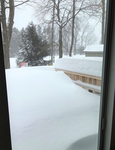
 The snow warning turned out to be for real.  We accumulated near 10" (sounds like a lot more if I say 20 cm.). and today it's blowing and drifting.  Our caregiver couldn't get here this morning, and maybe no-one tonight.  But our snowblower guy did come, so Mrs. F.G. has gone out for a bit.


I  tried to get two different views to show you how much it's accumulating, but I'm getting tired of taking pictures of just white!  Luckily I do have my last two Arctic posts almost ready to go, so you'll get something different.  Meantime, take care in this crazy winter weather.

We did keep track of birds for the Geat Backyard Bird Count, and saw a total of 4 species - several Chickadees, plus one Cardinal, one Red-bellied Woodpecker, and one White-breasted Nuthatch.  Oh, and one Crow.