
The challenge of labelling the geological layers here is that so many geologists have studied it, and since they all want to re-interpret things, they have labelled many layers, giving a quite complex description. But you can see some obvious differences even if you're not a geologist and I'm going to stick to the simple version!

The entire gorge here is about 175 feet deep, so the top layer is probably 50 feet thick, the next softer layer the same, the 2nd short vertical layer only about 15 feet, and the bottom slanted layer 60 - 75. Look up the stratigraphic layers and you'll find a lot more layers labelled, but the main four are enough for me.


Here in the valley that layer forms the cliffs of Old Baldy, and is known as the Amabel Formation. Regardless of name, this layer is the remains of ancient coral reefs, like today's Great Barrier Reef, that circled the Michigan Basin 400+ million years ago.
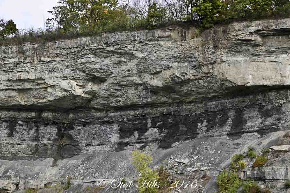 The next layer down consists of thinner layers of sandstone and shale. These erode more easily, and here form a slanted scree slope. But shale, being compressed clay, does not allow water to percolate through, so water is forced to move horizontally across the top, emerging as springs along the Niagara Escarpment. These water stains make that very clear in looking at this cliff.


The thin flat line crossing the east side of the valley here about 2/3 of the way up the hill, is the same formation. Here in the valley it's labelled the Manitoulin Formation, and it forms a secondary cliff, much smaller than Old Baldy, and perfectly flat because it was formed differently. As you can see, the sections above and below it are quite slanted, just as in the Niagara Gorge. (The gorge is much steeper simply because it's constantly being eroded at the bottom).

Here's a closer view of the Manitoulin Formation, where it forms the top half of Webwood Falls in the valley. You can clearly see how it's composed of thin flat layers of dolostone. Beneath it is the easily eroded shale layer known as Queenston Shale, usually showing up in bluish or reddish colours, both of which you can see here.

If you look at the entire cliff, all the layers below that top hard layer of Lockport Dolomite are formed as part of the delta of the Taconic Mountains to the east, 440+ million years ago. The Taconics were the predecessors of today's Appalachians, and are thought to have been twice as high as today's Himalayas. They formed an immense delta of sediments eroded to the west, as far as Chicago and the west side of Lake Michigan (and across all of southern Ontario). The entire lower 3/4 of this cliff consists of layers of muds, sands and lime deposits of that delta (that's why they're always so flat).
All in all I've managed to make sense of the geology of the gorge for me, but translated it in my own mind into the geology of the Beaver Valley. I'm satisfied that my simple understanding is enough!
It's great when rock layers get exposed like this. A great geology lesson for all!
ReplyDeleteI so enjoy when you talk geology.
ReplyDeleteAmazing photos and interesting geology.
ReplyDeleteKind of what our geologist friend calls naked geology. We found a lot of it with him in the California deserts. - Margy
ReplyDeleteI always enjoy a geology lesson - especially when I understand it! It makes for interesting scenery and photographs too.
ReplyDeleteGeology is fascinating! Love the description and the photos!
ReplyDeleteWonderful post and photos . It is amazing how the rock and cliffs form . Thanks for sharing , Have a good weekend !
ReplyDeleteVery interesting, FG. It's there for everyone to see, but it needs some explanation to really appreciate it. Thank you. :-)
ReplyDeleteThat explanation works very well for me!
ReplyDeleteGreat geology lesson. I found it fascinating.
ReplyDeleteI bet your daughter in Abbotsford sees Mt. baker almost up close and personal. Abbotsford is about 1 1/2 hours from our house. Small world isn't it.
MB
Wow! What a site! It must have been a fascinating project for you to learn its geology.
ReplyDeleteVery interesting explanation of the geology and how the strata continue over such a large distance. As someone who lives at the northwestern edge of the Appalachians, which are but 2,000 feet high here, the height of the ancestral mountains never ceases to amaze.
ReplyDelete