Thursday, September 5, 2013

Metcalf Crevice Side Trail

My third favourite trail along the Bruce Trail in the valley is the Metcalfe Crevice Side Trail.  This one is very short, hardly 0.5 km, but it's pretty adventurous for most people!  It goes directly through a large crevice in the Niagara Escarpment, and you have to do some rock scrambling up or down 4-6 foot rock walls to get through.

This is the crevice after you get in, with vertical rock walls on either side.  It immediately feels noticeably cooler than above, on the main trail.  This crevice is quite wide as crevices go, with lots of vegetation, which makes it look richly green.

Looking back, this is the entrance - a bit of a drop down some rocks with a toe-hold or two, but we took our 3 year old grandson through here as an adventure, and even grama made it through with a little care - mind you, she's a pretty adventurous grama.

 
Once you're there, it's a unique environment, with numerous ferns on the very moist vertical walls of limestone.  The trail goes through some rugged boulders, which are almost always slippery because of the high humidity, and in places you can feel the cold air blowing out from cracks in the wall.  You do need good solid hiking boots.

The most common fern is the Bulblet Fern, with its very long narrow tapering shape, and bright green colour.  It forms solid patches on the walls in places.

Here's one moisture laden rock wall, covered in moss, ferns, and liverwort.

The liverwort (on the wall in the lower centre of the previous picture) is a particularly fascinating plant, looking like green snakeskin, and thriving because of the cooler-than-normal temperatures and the high moisture levels on the limestone.

Eastern White Cedar are the most common trees above you on the escarpment, both on the vertical walls, and hanging over the rim 60-80 feet above.  This is perhaps the most photographed twisted cedar root along the entire trail!

All in all, this is a fascinating adventure, especially for kids, as long as you're careful!  It's found a concession south and then east of the hamlet of Duncan.  This is crown land, with a parking lot provided, so it's easy to find.  The outer cliff is a very popular rock-climbing mecca.  Follow the white blazes from the parking lot til you see the blue side trail sign and blazes; it circles back to the main trail below the cliff.


Wednesday, September 4, 2013

Cuckoo Valley Overlook

My next favourite walk on the Bruce Trail is the section south of Johnson's Sideroad to the viewpoint at Cuckoo Valley Overlook.  The trail wanders through forest punctuated with huge old trees on the side of the valley slope, past the top of a waterfall, up the stream and out into a high meadow - from which you get this view to the east.

You are looking across the upper Beaver Valley, into the much smaller Cuckoo Valley, where you can see the cliffs of the escarpment, and the green cedar trees along the top and below.  If you were able to fly over there and peek around the corner to the left, you would see this waterfall, Eugenia Falls.

This waterfall was the site of a 3-week gold rush in 1853, the Eugenia Gold Rush - until they figured out that the 'gold' was pyrite or 'fool's gold'.

The walk through the forest in mid-October is beautiful with the leaves turning.  I end up taking numerous photos.

 
Looking north you can look down toward the wider valley.  The tower on the right hand side is one of the surge towers on the Eugenia Power Plant, the second oldest in Ontario, 100 years old next year.  It would make a good story in its own right; my uncle ran the power plant in the late 1940's.

 
Through the woods you come out to the high meadow, and after trudging uphill a bit, you find a bench where you can sit and admire the view.  When we were there in October two years ago the New England Asters were everywhere.

Like most of the trail, you can also walk here in the winter - on snowshoes.  It's a bit of a long walk if the snow is deep and fresh, but if anyone has preceded you, it's easy.  I always stop to admire this cluster of 8 beech trees right beside the trail, so close together they're like one big tree. 

 And this huge bracket fungus sits on one of those beech trees.

The trail goes by the top of this waterfall, so you don't get much of a view, but I struggled down the very steep slope two years ago to get this picture, a 30 foot high frozen curtain of ice.  Do you understand now why this section is known as the 'Falling Water Trail'?


Tuesday, September 3, 2013

Favourite Walk #1

I think my favourite walk on the nearby Bruce Trail is a section that runs from Graham's Hill Sideroad north and downhill to reach Grey Rd. 30 on Bowle's Hill.  This section has a variety of habitats, a major sinkhole, some huge old trees, a unique double waterfall, and a deep ravine carved by a tumbling stream.  It's only a little over 2 km long, and downhill, the perfect walk for me.

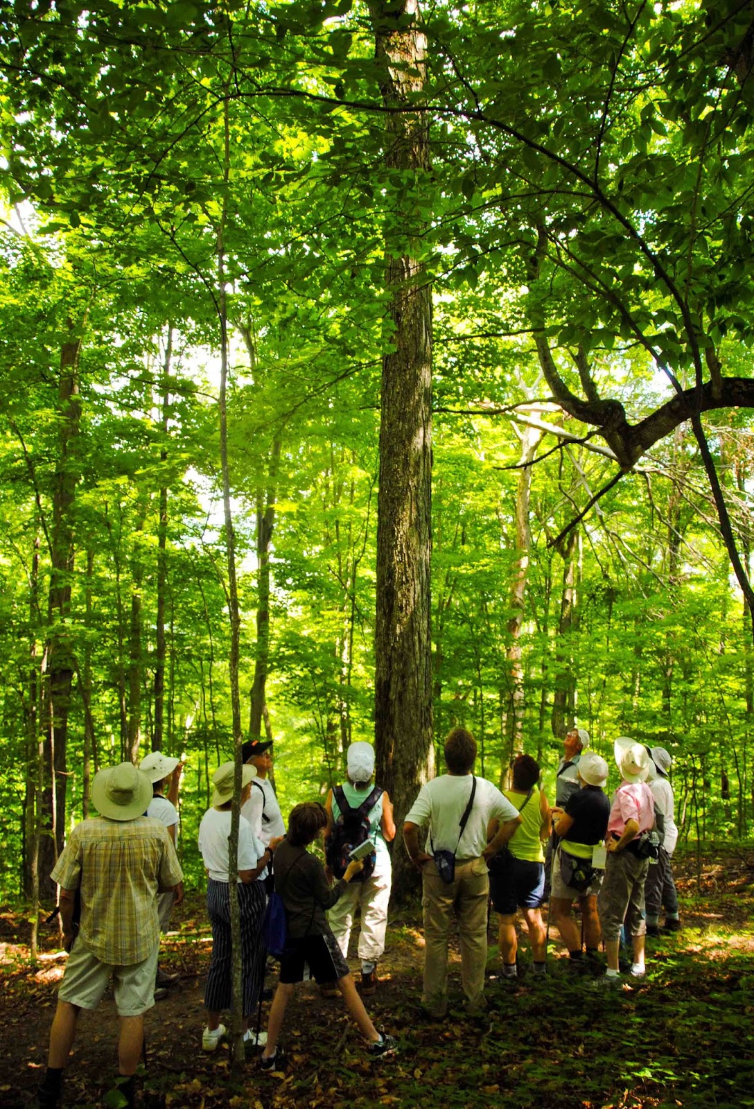
The highlight of this section for me is about an acre of true old maple-beech forest, with some ancient sugar maple and American beech.  These are forest-grown trees, so they're not huge in diameter, but they are tall and straight, and what I would call 'old growth'.  In fact, I've hardly ever seen a stand of trees of this quality anywhere else in southern Ontario.  This is a group of Bruce Trail walkers admiring one of the trees.

And this is the Sugar Maple they're admiring, at least 60 feet to the first branch and 2 feet in diameter.  Even a single tree like this would be a unique feature along the trail. 

This is the largest sinkhole along the trail, about 20-30 feet deep and 60 feet across, potentially quite dangerous to descend into, but representative of the widespread karst features in this area which is all limestone bedrock.  There are 8 or 10 on this property, all dry sinkholes.  (Elsewhere near here are sinkholes with disappearing streams which reappear below the escarpment as springs - but that's a story for another time).

Part of the initial stretch of trail here goes through a pine plantation, which as you can see by the picture above, badly needed thinning.  The trees were too tall, too thin, and too crowded, so last year we organized an assessment by a forester, and had the thinning done in March.  This is part of the pile of logs that resulted.

There wasn't much profit, but it was enough to pay for all the work that got done, and in the future we'll have a much more ecologically diverse forest as a result.  Tomorrow I'm going out to take photographs for the baseline monitoring to follow up on the thinning operation.

You can snowshoe the first portion of the trail through here, though in deep snow the trail down in the ravine would be almost impossible.  Winter trail use is increasing all along the Bruce Trail with the advent of the smaller aluminum snowshoes that everyone has now.  I've been on winter walks where no-one had actually seen anyone use the 'real' snowshoes - though I have 3 of them, in different sizes for different snow conditions.

As you hike north, you head downhill a little, hear the running water, and suddenly come upon this unique tumbling waterfall.  The geology of the area determines the structure of the waterfall, with a vertical cliff at the top followed by this long step-like eroded channel down the slope, to another vertical drop below, followed by the tumbling stream in the ravine.  The unique ski chalet at the top sits on top of the stream - though it wouldn't be allowed under today's planning rules.

 This is the lower falls, hard to get a picture of behind the trees except in winter or early spring.

And following this the small stream tumbles down a steeply-sloped ravine carved in the Queenston Shale that accounts for so many of the steep slopes of the valley.  There are two stepping stone crossings of the stream - this one now replaced by a brand new bridge, built by another team of volunteers three weeks ago.

We've only gone about 2 km of 900 in the overall Bruce Trail, but it's a very interesting 2 km.  Tomorrow we move south to another section with another waterfall.  No wonder this section of the trail is informally known as the 'Falling Water Trail'.

Monday, September 2, 2013

Celebrating the Bruce Trail in the Valley

It was 50 years ago now that the idea of the Bruce Trail was hatched, and a group of people in the Beaver Valley first got together to try and make this section of it a reality.  The 50th Anniversary Celebration is coming up, so I'm going to make my little contribution here this week, telling you about four of my own personal favourite trail walks.

For me, the Bruce Trail means a walk in the woods.  There are many sections of trail that wander near the edge of the Niagara Escarpment, through beautiful forest.  There's wildlife, ferns, trees, wildflowers, and a sense of peace I get from a walk in the woods.  The trail also goes through farm fields, along the cliff edge, through meadows, and sometimes just along roads, but the woods, especially in spring, represents the trail for me. 

Just one of many rare plants along the escarpment, the Hart's Tongue Fern - here the left-over evergreen fronds from last year that lasted under the snow - is a symbol of the trail for many.  The original idea was to follow the Niagara Escarpment in Ontario, and this fern only grows in the limestone rock along the escarpment, just one of many special features of the trail.

What amazes me most now that I live close-by and volunteer for the trail myself, is the number of retiree volunteers who keep the trail available for all to hike.  The Beaver Valley Bruce Trail Club, which cares for the section in this area (one club of nine in the Bruce Trail Conservancy), is run entirely by volunteers, and an amazing 30% or so of the members actively volunteer as Trail Captains, Land Stewards, Organizers, or Hike Leaders.  I'm sure another 30% have volunteers in the past.  It is really the efforts of these people (150 or so at the moment), who we are celebrating in the 50th Anniversary.  This boardwalk was built by volunteers two years ago.

The wildlife and wildflowers along the trail never cease to amaze me.  This is hepatica, one of our earliest spring wildflowers.  For me, when I see the beauty in the woods along the trail, I always think of the private landowners who make the trail possible.  Hundreds of landowners have allowed the trail to cross their land based on handshake agreements, and this is the fundamental reason the trail exists. Thanks for sharing the beauty.

The trail is great in the winter too.  We get lots of snow (usually), and snowshoeing is increasingly popular.  The local club runs regular hikes all year-round, including winter ones on snowshoes.  The white blazes as on this old beech tree mark the trail for all hikers (blue blazes for side trails).

I knew several of the people who originally came up with the idea for the trail in the early 1960s, and went on my first Bruce Trail hike about 1964.  It's nice to know that an idea originally developed and put in place by volunteers has flourished so well. 

Parts of the trail go through farmland, like this path through a hayfield, and the Bruce Trail Conservancy actively raises funds to purchase land corridors where it can, to provide a permanent route.  Farm fields are leased back to farmers, as in this case.  Hayfields provide excellent habitat for bobolinks, now a threatened species in Ontario; the Bruce Trail Conservancy supports conservation objective as well as hiking.

This is Webwood Falls, on a property recently donated to the Bruce Trail.  Landowners increasingly look to the trail when thinking of selling their land, and a surprising number donate land.

Let me add a few caveats before I present my four favourite walks over the next four days.  Note I said 'walks'.  I'm not a 'hiker', I'm a 'walker'.  I go slow, I look around, I always have my camera, and I like to stop and enjoy the moment.  I get tired going up hill.  So the four walks I've chosen are all short, relatively easy and scenic; many Bruce Trail hikers would have others, likely over longer stretches of the trail, as their own favourites.

The Bruce Trail is an important part of our world here in the Beaver Valley; 
link here for other places round the world:

Sunday, September 1, 2013

Where are the Monarchs?

I thought I had finally seen a monarch butterfly this summer when I spotted this bright orange and black butterfly near the Beaver River in Clarksburg.  Managed a few pictures of it, mostly hidden behind the Joy-Pye-Weed.  But alas, when I got it home and enlarged it a bit, it's a viceroy, not a monarch - nothing against the viceroys, but where are the monarchs?!

You can identify this as a viceroy by the black line in the middle of the hind wings, which is absent in the monarch.  Citizens and scientists all across the mid-west and eastern Canada are concerned about the dramatic drop in the monarch population this year.  One report indicated 90% fewer monarchs than last year!  

 
Reports put the decline down to the severe drought in the mid-west last year, to the cold wet spring in eastern Canada this year, and to the increasing use of round-up and neonictinide pesticides on fields of corn which used to allow for weeds like milkweed along the edge - but no more, with widespread 'clean' farming.

You can watch the progress of the monarch migration on the website 'Monarch Butterfly Journey North', a citizen science website where you can submit your own observations.  It even has maps that show the pattern of the migration.  Could we be seeing the beginning of the end of the monarch butterfly?

This is another butterfly I've seen this summer, one I didn't know before, the Red-Spotted Purple sub-species of the White Admiral.  It looks like a totally different species to me, with the blue on the wings, but the guide says the two are just sub-species.  In fact, this one does look like it's half-way in between based on the book I have, with a bit of a white band through both the upper and lower surface of the fore-wing.

Summer's over now, and early fall is here, but it will be a sad summer to remember if it turns out to be the start of the loss of the amazing monarch butterfly.  No other species that we know of migrates the 4000 km the monarch does, over 3-4 generations of butterflies - how does the future generation know to go back to Mexico when it's never been there!!??

Saturday, August 31, 2013

Water Droplets in the Schmir

It was another misty, rain-saturated morning here, with fine drizzle or 'schmir' on and off all morning.  But I found some amazing patterns of water droplets on certain plants.

Clematis blooms.

Purple Smoke Bush.

 Clover in the lawn.

 Yellow Smoke bush.

A grass.

Some plant seem to hold the water droplets on the surface just waiting to be photographed, but many don't.  It must be some type of waxy coating that account for the plants where the water droplets are so obvious.  Also caught some cobwebs, and wide blades of day lily leaves - but they might be for another day.


Friday, August 30, 2013

Crocosmia hiding behind the fence

I like the beautiful crocosmia flower for both it's bright red flowers, and the brilliant green long spiky leaves.  So I was glad when we got a couple for the garden.  We planted it against the fence, where we thought it would show up well - but the plants beside it exploded in growth and have rather overwhelmed it.  The result was that most of the red blooms showed up through the fence on the backside of the garden!


 We've also got one orange version of this plant, with these two flowers in bloom right beside each other.

Linking to: