Saturday, March 7, 2015

A Seasonal Marker - the Sun Marches North

You may remember that I'm following a tree for a year, posting monthly updates through the seasons.  My tree is this Butternut tree in our fencerow beyond the shed which I see every morning from my chair where I read blogs while enjoying my morning coffee (and take sunrise pictures through the window).


This was totally unplanned, but the last few weeks I've noticed how the Butternut, which you can recognize by its silhouette, is serving as a marker for the northward movement of the sun - specifically the point on the horizon where the sun rises.  So I went back to December, and found this picture, the closest I have to the winter solstice.

By mid-January you can see that the point at which the sun rises has only moved a little to the left of those trees.  I'm looking southeast for all these pictures, taken from the same window, so the leftward movement of the sun is actually a move to rise further north.

This was the morning that struck me as an emerging pattern.  Suddenly, by mid-February, the sun had jumped a long distance, to rise just beside the Butternut tree.  And I know from past reading that the speed at which the length of daylight changes varies over the year, with the changes slowest hear the solstice and fastest as we approach the equinox.

Only two weeks later, the sunrise had moved well beyond the Butternut (and we've started to have a lot more sunny days).  The point at which the sun rises is moving faster and faster to the north.

And only ten days later, yesterday, the sun had moved considerably further again.  It's now reaching the point where the angle is so sharp I won't be able to take pictures of the sunrise from that window much longer!

So my Butternut Tree has inadvertently turned out to be a very interesting marker of the seasons, giving me a reference point for the rising sun.

I haven't actually put on the snowshoes and tramped out to see the tree, and I find myself wondering how it survives the bitterly cold nights we've had - this is the lowest temperature it had to endure this winter.  But it does survive, and Butternuts grow even a little further north in Ontario than here near the south shore of Georgian Bay.  Maybe by next month I won't need the snowshoes to go and visit my Butternut!

Linking to:

Friday, March 6, 2015

Weaver Falls

I was in Owen Sound the other day and after my cardiac rehab appointment, continued my quest for frozen waterfalls.  Weaver Falls is a small falls on a tiny creek that joins the Sydenham River flowing through Harrison Park, an old and popular park south of the downtown.  I've been visiting this park since shortly after I was born, as my grandparents lived in Owen Sound and an outing to the park was one of their favourites.

However, in all the years of going there, my parents never took me up the short trail up to Weaver Falls until last year I visited it myself.  It's only a short distance, but perhaps less well-known than all the other big waterfalls in the area.

A good deal of it is on an elevated boardwalk, making for easy walking and some interesting views in the narrow ravine.

You go round about the third curve, and there is the waterfall in the distance.  Unfortunately the last 100 yards is private land (and a very narrow, steep-sided valley), so the trail ends before you get to the falls, and the view is on a sharp angle.

On this trip I actually took my tripod, and this was only the 2nd of five falls with open flowing water.  In fact there didn't seem to be much ice at all, just lots of snow.

I played around with settings and a neutral-density filter quite a lot, trying to get a 'slower' picture of the falls, while my fingertips became completely frozen (it was about -20°C).  I couldn't even feel the camera buttons; I had to look at my fingers pressing them to know what I was doing!

To be honest, I'm disappointed in the results, though experimenting is how you learn.  There seemed to actually be some mist rising off the water, which suggests that it's warm enough not to freeze.  I believe that it emerges in a spring not far above the falls, but I need to check that out next summer.

At least it was a bright sunny day, and my fingers came back to life after 10 minutes in the warm car!  Two more much larger frozen waterfalls still to come!

Linking to:

Thursday, March 5, 2015

Late Winter Skies

Even though our world here will be white for another month or so, one big difference I notice when we get to late February and into March is the number of sunny days with beautiful deep blue skies.  Even while the temperature stays cold (it was -29°C or -20°F this morning on the thermometer), the sun is rising earlier, soaring higher in the sky, and setting later.  If there's no wind chill you can feel the warmth of the sun on your face at well below freezing temperatures!

On these days over the past week, which were all chasing waterfalls days, I really noticed the blue skies, all made more interesting by white clouds blowing over.  This is Lake Eugenia, still solidly frozen.

I was really shooting the sky itself, but started looking for focal points that would make it more interesting, trying to place them down low and off to one side to maximize the blue.

Although it's hard to capture in a photo, one thing I like about driving around our valley is the way you often just get a glimpse of something over the edge of a field or in between the rolling hills.

This small barn which sits all by itself strikes me every time I drive by.  I really must walk over and explore it once the better weather arrives.

It has sat undisturbed in this field, with no other buildings nearby, as long as I can remember.

Often it's the valley itself that you just get a glimpse of, a band across the view that the human eye notices, but the camera can't really capture well.  Once you get a little further north of our location the valley widens out and this is the typical view you get driving over the edge and down.

When I try to divide our long winter season into recognizable chunks, the blue skies and strong sunlight of late February and into March are the most obvious difference I can see, so this marks 'late winter' in the valley for me.

Linking to:

Wednesday, March 4, 2015

Winter Fences

As you might guess, I'm seeing plenty of ordinary things as I drive around in search of frozen waterfalls and other scenery.  So here are a few of the interesting fences I've seen.  Ever since I started linking to the 'Good Fences' meme, I've been much more aware of the little things I see along the way like these.

I posted a picture of this fence in January, showing a really neat shadow, when we still hadn't accumulated much snow and you could see the fence in the distance.  Now it disappears in the snow fairly quickly as it heads west.

This fence is beside one of my favourite valley viewpoints, so I find myself there fairly often, and I like that small unused barn sitting in the middle of the field.  The stile is for the Bruce Trail.

And this is actually the same fence, taken in the opposite direction.

Here's another fence that disappears into the snow to the right.  And I know from last year that this will flood in April, and the fenceposts will be sticking up out of the water.  You could put together a series of seasonal pictures on just about any topic!

I've been intending to show a typical snowfence for those of my readers from further afield.  This was taken in December when winter was refusing to arrive.  It's glowing read in the light of an evening sunset.

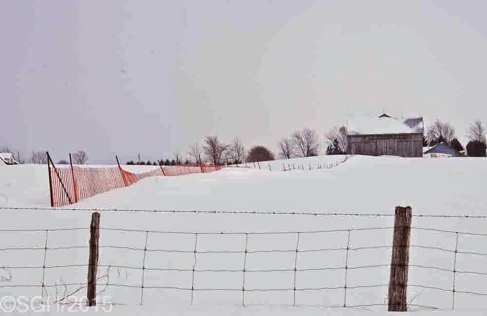
And this is the same snowfence a few days ago, for most of its length only the posts sticking above the snow.  Put up properly they significantly reduce the drifting on the highway to the left.

Linking to:

Tuesday, March 3, 2015

A Frozen Webwood Falls

I did make my destination yesterday, heading down Sideroad 25 to find Webwood Falls.  This was a very short but challenging snowshoe walk, as no-one had been in to the viewpoint over the falls, and I had to find my way through very deep snow - after climbing the 4 foot snowbank.

Sideroad  25, with a view of the west side of `Blue Mountain` and a completely frozen Georgian Bay in the distance.

Here`s the totally frozen Webwood Falls, just a huge pile of ice where Fairmount Creek drops over the edge of the Manitoulin escarpment and starts carving a deep ravine downstream.  No sound nor sight of running water.

It`s a difficult waterfalls to photograph at the best of times because of the trees in the way - this would be the best viewpoint if it weren`t for the trees.  And those little branches play havoc with your auto-focus too.

I did manage to tramp around to another safe spot behind some trees and lean through to get this photo.  A better photo would require descending the ravine, the sides of which are far too steep to allow this safely.  Someplace under that ice water is running.

Like all these waterfalls I`ve described, there was an old mill here years ago.  There are two bits of stone wall remaining, shown here, just above the falls.

On the other hand, the stream above the falls was still partly open and running.  I could hear it gurgling away as I climbed another snowbank to get this picture.

And down in the ravine there was at least a little open water, so I know that water is flowing over the falls.  In this view you  can see the steeply-sloped ravine this creek has carved.  In fact this waterfalls is geologically different from the three previous ones I`ve featured the past few days.  They all fall over the Amabel dolomite, and then tumble gradually downstream.  But this falls tumbles over the Manitoulin formation, and then carves a ravine through the highly erodable Queenston Shale formation below - the result is a much more steep-sided valley.

Linking to:
Monday, March 2, 2015

A Beautiful Winter's Day

Well, the bitterly cold temperatures have broken; it's skyrocketed to a balmy -10°C (still with a brisk wind chill mind you), and the sun was out bringing bright blue sky between the clouds.  I headed out to find my 4th frozen waterfall, and picked out a number of interesting things to illustrate our beautiful winter's day here in the valley.

From the top of the old Talisman ski hill, the view was clear today, looking northeast down the lower valley and all the way to Georgian Bay, that thin white line on the horizon.  Renovations to the old ski lodge at the bottom of the hill are coming well apparently, and it expects to open as the 'Talisman Mountain Springs Inn' later this year.  There is a major spring on the property that  provides water to the village of Kimberley.

Looking straight east across the valley you can pick out Sideroad 7 which goes downhill behind the trees on the right, all the way across the valley and up the other side.  In the centre of the picture are the cliffs of Kimberley Rock or Old Baldy, as it's locally known.

Even though it was a clear sunny day, the brisk wind was blowing and sculpting the fluffy inch of snow we got last night into new drifts that accumulated quite quickly.

On the way north and east to find Webwood Falls (tomorrow's post), I caught this glimpse of Blue Mountain and another angle on Georgian Bay in the distance, here a white line between the trees.  The snowbanks were a little high on this road!

Frequently on a day like this, even though it's sunny, you see snow being blown across the road from the existing snowbanks.

Sometimes it's enough to pretty well cause a whiteout, but typically they only last for a very short distance.  You just have to be careful not to veer into the other lane when you drive through them!

Summer road graders get outfitted as winter snowplows around here, and today was a pretty easy day for them, just keeping those drifts cleared away.  All in all, just a beautiful winter's day.

Linking to:

Sunday, March 1, 2015

Eugenia Falls

Eugenia Falls, the third waterfalls I visited this week, is particularly interesting because it has so much history associated with it.  All the waterfalls around here had mills of one sort or another built at them, but Eugenia Falls had a gold rush!  And it is still linked to an operating hydroelectric plant.

This is the typical picture of Eugenia Falls, usually a double stream of water (right now it's ice), falling over nearly 100 feet of the limestone cliff leading down into the Beaver Valley.  This is the closest you can get to have a full view of the falls (unless you're a drone)..

But a telephoto view reveals the frozen double cascade with it's slightly bluish colour.  Above Eugenia Falls is a small hydro dam creating Lake Eugenia, from which water is piped to a small hydro plant further north down the valley.  At this time of year most if not all of the water is siphoned off for the hydro plant; I could neither see nor hear any trace of flowing water here at the actual falls.

But you can get much closer to the falls, though the view is on a sharp angle, and you can't really see the second column of ice which is right down the cliff underneath you.

I liked this view even though it's partly obscured, because of the curled old cedar branches, and the increasingly blue colour of the ice.

Close-up, although taken through a screen of bare branches, the ice is amazing.

The gold rush at Eugenia Falls exploded in 1852, attracting many from some distance away - but it was very short-lived, as after 3 weeks they realized it was just pyrite or fool's gold, and all the fortune-seekers dispersed.

I've spent months trying to replace my dead computer, and making sure I had copies of all my pictures to transfer.  I've finally done it; this is my first post from the new computer and workstation.

Linking to:
/