Now that you know about the discovery of ancient indigenous hunting sites of the Alpena-Amberly Ridge, lets move a little east and look at the stretch of water between Tobermory and Manitoulin Island. Tobermory sits at the northernmost tip of the Saugeen (Bruce) Peninsula, and is known for its offshore islands and shipwrecks (two right inside the harbour). The area is now encompassed by the Fathom Five National Marine Park.
The Niagara Escarpment that creates the eastern shore of the peninsula continues as the east shore of these islands, all the way to Manitoulin. And with divers exploring 24 shipwrecks, scientists have discovered both ancient tree stumps and a gigantic submerged 'waterfall'!
This map is intended as a wall hanging, but it's the best I've found to show the location of that ancient waterfall, in dark blue. This waterfall formed during that Lake Stanley phase of the Great lakes, and necessitated a river flowing from Lake Stanley to Georgian Bay, creating this waterfall.
In those ancient days there would have been an actual waterfall, said to be larger than Niagara Falls today, but of course now that it's submerged, there isn't any water that's actually falling. The white somewhat triangular-shaped island where the deeper water channel seems to begin is Flowerpot Island, where our family camped in about 1967. I never dreamed a big waterfalls was just offshore!
We get a different view in this bathymetric cross-section, the peninsula on the left, and Manitoulin on the right. The river channel leading to the falls is clearly shown, leading to that deep plunge pool offshore. There's a secondary river and waterfalls on the right hand side, between Fitzwilliam Island (the arrow-head shaped one) and Manitoulin.
I'm just blown away to learn this and see the diagrams, since we once had a cottage on Manitoulin, and made the trip by ferry at least 40 or 50 times, as well as visiting Flowerpot Island.
At the lecture that sparked these posts, one of the things Lenore mentioned was ancient legends of the elders from Neyaashiinigmiig (commonly known as Cape Croker), the closest community of the Chippawas of Nawash that suggested a land bridge between the peninsula and Manitoulin. I'm not sure it would have been a 'bridge' as we understand the term, but there was certainly a lot of dry land around the islands.
Returning briefly to the research on the Alpena-Amberley Ridge, as well as the drive lanes that the researchers discovered, the divers took samples of the soil and remaining vegetation they found. By bringing up samples of the sediments and analyzing them, they built a picture of this ancient landscape.
Professor Lisa Sonnenberg of McMaster University, led the analysis, finding that this ridge would have had small trees and shrubs interspersed with wetlands, giving the appearance of today's today's Hudson Bay This is one of the stumps they found.
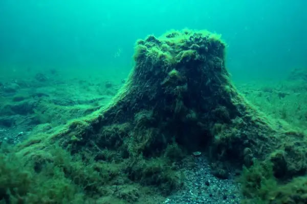
It's not too big a surprise then to read that National Park researchers have encountered stumps in several location in Georgian Bay. This is another of those stumps.
"Chippewa elders of the Cape Croker reserve have long repeated ‘legends’ of their ancestors being able to walk from Tobermory, at the Northern tip of the Bruce Peninsula, to Manitoulin Island, an area that, today, is covered by 90 km of water," I guess it's true!


Our earth looked so much different back then. Really interesting and to get your mind around a submerged waterfall rather than just a shear cliff underwater.
ReplyDeleteThe elders have much to teach us. Amazing! Thank you for sharing.
ReplyDeleteMost people dismiss the tales or legends of their forefathers, but when the evidence is there.
ReplyDeleteStay Safe and Enjoy!
It's about time.
I have read your last three posts with great interest. You have been busy researching. Thank you.
ReplyDeleteWe have visited Manitoulin, and Tobermory, so fascinating to read about what we had no idea is there!
I have been appreciating these posts and learning a heckuva lot more than I knew. Both the geographical research and legends are fascinating. I find it amazing that there is evidence in both realms.
ReplyDeleteI agree with AC. I am learning so much from these posts.
ReplyDeleteA fascinating and very informative post. Thank you so much for sharing ❤️
ReplyDeleteAnother good post ... and I like the picture of the stump.
ReplyDeleteAll the best Jan
Very interesting. Recent research has shown that Native Americans/First Nations have been on the continent far longer than was previously believed, so it's no surprise that cultures with strong oral traditions would know about things that happened as the glacier retreated.
ReplyDelete