It occurred to me that you might get more out of my post about watching hiking videos if you knew a little about the hiking trails I was referring to, so here's some background info to help your understanding. The three main long distance trails in the U.S. are the Appalachian Trail, the Continental Divide Trail and the Pacific Crest Trail. Together these make up the 'Triple Crown' of hiking.
Appalachian Trail (AT) - The AT is about 2200 miles long or 3500 km. for us Canadians, and typically takes about 5-7 months to complete as a thru-hike. Of course people hike smaller sections of it, or hike into beautiful viewpoints like McAfee's Knob in Virginia, but the hikers I follow are thru-hikers.
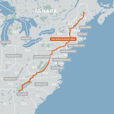
The trail starts on Springer Mountain in Georgia, and ends 14 states later on Mount Katahdin in Maine. Hikers have to plan how they're going to get both food and water along the way, but towns are frequent enough that they can get off trail every few days to resupply themselves. And there are plenty of fresh water streams along the way. There are numerous shelters along the way, but most hikers seem to prefer putting up a tent nearby rather than have the mice families in the shelter for company!
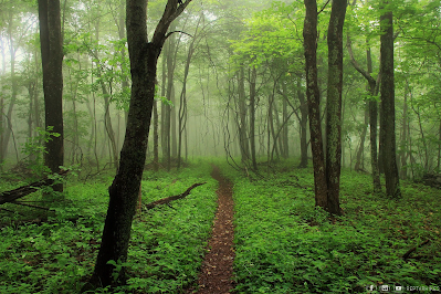
The trail is frequently rainy, but this trail is very popular, and you'll probably never be far away from other hikers. There are many local hikers in places, given the population of the nearby eastern seaboard. Thru-hikers often end up travelling in small groups once they find others going at a similar pace, a group known as a 'tramily' or trail family.
Continental Divide Trail (CDT) - The CDT is 3100 miles or nearly 5000 km. and typically takes about 6-8 months to complete. This trail gets far fewer thru-hikers (or hikers of any kind) than the AT, so you're much more likely to spend some time alone in these miles.
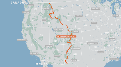
The trail starts in the southwest corner of New Mexico, ends in the northwest corner of Montana, and wanders through 5 states. This is the only one of the three long-distance trails that is not yet complete, necessitating some road-walking. It's also the only one of the three that has some alternate route choices; in fact there are quite a few alternate routes, and you'll have to do some serious planning both to start out and along the way.
Food and water sources are a much more serious issue here. Sources of water are few and far between in places, and in other places consist of cattle-watering troughs. As one guide wrote: "Be mentally prepared to drink from mud puddles full of cow poop...", along with a few dead mice and lizards floating in the dirty water. This necessitates having a water purification system with you. Towns are few and far between too, necessitating much more careful food planning.
The CDT is certainly scenic, but given the alternate routes, scarce water and few towns, it is recommended that you hike the AT or CDT first to gain experience, and you will need advanced navigation skills with a map and compass as well as whatever electronic navigation aids you carry. Thankfully, there are numerous information sources and excellent annotated maps available online. There might be some health challenges given the high elevation of some parts of the trail reaching the low Oxygen levels of 14,000 feet.
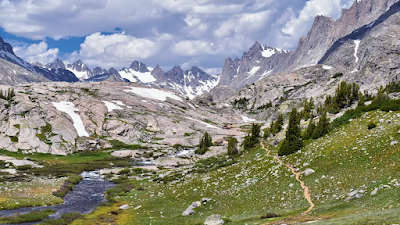
Pacific Crest Trail (PCT) - The PCT is about 2600 miles long or 4300 km. It generally takes from 5-7 months to complete, with the Sierra Nevada section including several high dangerous mountain passes. But the scenery is spectacular!
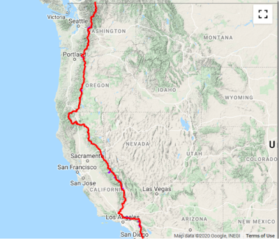
The PCT can be divided into three sections, the southern desert, the central Serra Nevadas, and the rainforests and nearby spectacular mountain peaks of Oregon and Washington. In the first of these water sources is the challenge, in the northern section, it may easily be getting late in the season, bringing cold temperatures and snow.
But the middle section, the Sierras, is the most spectacular and the most dangerous. Hikers must climb high in the mountains to cross several mountain passes where snow conditions make an enormous difference. They must have ice-axes and bear canisters and know how to do self-rescue on the extremely steep snowfields they have to cross. Self-rescue means rolling to face the snow and jamming your ice axe in to prevent yourself from sliding 1000 feet plus down the slope! You must also be prepared to ford raging mountain rivers during the snowmelt. Under no circumstances should you hike this section alone!

This photo shows hikers inching their way to the 13,000 foot top of Forrester Pass in California. It actually looks like mountain climbing to me, not just hiking. One video I watched did feature a description of a hiker losing her footing and starting to slide, luckily self-rescuing herself immediately but having to hang on desperately until rescued properly by two companions. The PCT is also subject to closures due to forest fires, necessitating detours of some distance sometimes.
I hope these descriptions give you some sense of what's involved in hiking these trails. Even though my hiking days are over I find myself fascinated learning about them!
There are of course long-distance trails elsewhere in the world, but there are only two I've watched videos of.
The Camino de Santiago, a famous trail across northern Spain is really a network of pilgrimage pathways as old as 1000 years leading to the shrine of Saint James in the great cathedral of Santiago de compostella. The most popular route, from the nearest corner of France, is about 500 miles or 800 km. long. A Canadian from Thunder Bay walked this pilgrimage in 2018 and her videos are all posted on YouTube under the name Samantha Plavins.
The Tour de Mont Blanc is a circular route, and a much more scenic route, in the mountains of Switzerland, France and Austria. Spectacular scenery but only 110 miles in comparison to the above trails. It encircles the Mont Blanc massif, a group of 11 peaks over 13000 feet, the highest being Mont Blanc itself, the highest peak in western Europe.
Our own Bruce Trail here in southern Ontario, at about 900 km. in length, is hiked every year by 'End-to-Enders', but rarely as a thru-hike. It is not really set up well with either shelters or camping sites.
If you want to see what the features of the Appalachian Trail are as an example, I've just watched a terrific video compiled by Taylor the Nahamsha Hiker, entitled 'All the Best Spots', the landmarks of the trail that appealed to her. Taylor, who runs a gift shop in New Hampshire called 'Nahamsha gifts', is a bright enthusiastic young woman who hiked the AT in 2021 in only 120 days - that's fast!
It's a fun video to watch giving you a hiker's perspective on this trail.
I should say that I never intended to imply that you might be interested in watching well over 100 videos of someone hiking the AT from end to end! But remember I'm forced to lie in bed awake for an hour or two every night, and I learn a heck of a lot more from these videos than from Facebook! And also remember that as long as I keep my brain occupied I don't notice the chronic pain.
Thanks for that useful background information. The only one I've managed is the Tour de Mont Blanc (which runs through France, Switzerland and Italy, by the way, not Austria). I remember this because we engineered our walk to spend as many nights in Italy as possible - the wine was a lot cheaper there in those days!
ReplyDeleteCompany as you hike, food drop offs, down here many years ago Graeme Dingle and Jill Tremain did a winter traverse of the Southern Alps. This was in 1971, I am guessing not a digital camera or cell phone with them back then. They had food drops organised, and Graeme wrote a book after they returned to Wellington. I am sure there will be books about your Northern trails too.
ReplyDeleteKeep your brain working, too many folks our age put their brains away to rest and it's all downhill from there. There are so many beautiful places to see that none of us will ever live long enough to see but a tiny fraction of them.
ReplyDeleteI've been to the north end of the Appalachian Trail and that mountain.
ReplyDeleteI've walked little bits of the Appalachian Trail over the years.
ReplyDeletePart of the International Appalachian Trail goes through eastern PEI and along the northern peninsula of western Newfoundland. Beautiful areas to hike!
ReplyDeleteI can see why you watch the hikes both to pass the time and also to distract yourself from pain. As you say, much better than FB.
ReplyDeleteWonderful information, though my interest is just in the sites being viewed at this point. I have done a bit of the AT in the Smoky Mountain Park, and seen the beginning of the AT in Georgia in a lovely waterfall park. We have a new trail called Mountains to Sea in North Carolina, going east/west as opposed to all these n/s trials.
ReplyDeleteMy backpacking days are behind me, and I too enjoy very much hearing and reading about intrepid hikers along these trails. Going out on five, six, even seven mile hikes these days is challenging, but I do enjoy being out there in the forests. When I lived in Boulder, I did several days-long solo backpacking trips. That was then, and my memories are still alive and well. :-)
ReplyDeleteMy former brother in law hiked the Inca Trail to Machu Picchu, he posted many photos on his facebook of the hike before he died of bone cancer. He always took photos of flowers for me:)
ReplyDeleteIf I was young again , I would certainly triysome of these trails.
ReplyDeletehave you read Bill Bryson’s book about walking the Appalachian Trail. I think it’s called A Walk in the Woods. It was kind of funny, at least in the audio version that we listened too quite a while ago now.
ReplyDeleteI remember seeing a road crossing for the Pacific Crest Trail in Warner Springs, California as well as a trail head at Eagle Rock a few miles south of the road crossing. It would sure take a lot of stamina to hike any one of those 3 trails.
ReplyDeleteA friend of mine did part of the Camino de Santiago a few years ago, and I followed a blog of a couple who did the entire walk. To be honest, I can't imagine ever doing any of these hikes and the one on the Pacific Coast would never be on my list.
ReplyDeleteMy son lives near Bar Harbor, Maine. He has tried to do long stretches of the Appalachian trail. He worked out on Cadillac Island on an internship and never left the area.
ReplyDeleteI've hiked small sections AT but they add up. I live in Virginia and a lot of it runs through here.
ReplyDeleteOh, are you familiar with the American Discovery Trail?
DeleteNo I'm not. I'll look it up.
Delete