Sunday, August 25, 2019

St. Kilda

Taking you to Orkney and reviewing our photos of that great trip to Scotland has got me going, so you're going to have to put up with a few more Scotland and England posts before I return to reality.  Before we docked on Orkney our previous stop (we're doing this backwards) was the remote, isolated island of St. Kilda, 40 miles out in the Atlantic west of the Outer Hebrides.

We were remarkably lucky to get calm weather in the north Atlantic on the day we visited.  Passengers on most cruises don't even get to land.  The St. Kilda archipelago includes several rock stacks rising abruptly out of the grey water, and the one inhabited island, Hirta (in the distance).

The rock stacks like this one are amazing, rising straight up out of the water, several with no safe landings (except for the birds) at all.

 
Sailing into Village Bay, you can see the medieval stone houses in a line across the slope, as well as the British missile tracking range towers on the horizon.  The entire island is grazed by sheep.

A closer look shows the 6 houses rebuilt by National Trust of Scotland volunteers since 1955, as well as some more modern Ministry of Defence buildings.  Transferring by zodiac (we were only the second of 5 ships from which passengers could safely disembark that year), we headed to explore the island.

The island population was known for its remarkable daily morning meetings of the men, deciding on the tasks for the day.  In recent centuries the total population has never reached 100, so it was only a few families involved.  Historians have made much of this democratic 'parliament' where the men gathered in this 'street' in this 'free' , but very isolated, society.  Islanders have been described as healthier and living in better conditions than most in the larger Outer Hebrides during the mid-1800's, the era of the notorious clearances.  There has never been a serious crime in recorded history.

The island's population dropped further when 36 islanders emigrated to Australia, upset over the religious divisions in Scotland in those years between the Church of Scotland and the Free Church of Scotland, both strongly Presbyterian.  Influenced by early tourism and the military during WWI many young men left for a better life, and by 1928 only 37 people remained.  In 1930 they made a collective decision to leave, encouraged by the island's nurse.  They were resettled in Morvern.  The last living islander died in 2016, having been evacuated when she was only 8.

There are numerous stone storage buildings or 'cleits', as well as garden enclosures (to keep the sheep out).  All built of drywall construction; they were roofed with turf.  The houses were traditional Scottish 'blackhouses'.

We made a considerable uphill hike out of it - yours truly in the years before the wheelchair.  The vertical scar on the cliff in the background has proven to be a Neolithic age quarry, showing St. Kilda to have been occupied for several thousand years.

Looking down on our adventure's cruise ship.  Islanders had a tougher time of it, usually taking several days for sailing or rowing to the mainland, after perhaps months of waiting for good weather.

There are 3 unique species on St. Kilda, having evolved through centuries of isolation.  These is the Soay sheep which are left to graze and survive with no shepherds.

And this is the tiny St. Kilda Wren, right in the middle of the picture.  There is also a St. Kilda Field Mouse.


But by far the dominant wildlife are the birds, especially one of the world's largest colonies of Gannets, but also Puffin, petrels and fulmars.  These birds and their eggs were the main source of food for the islanders besides the few potatoes they could grow.  Men and boys scaled down the cliffs on ropes to gather the eggs and the young birds.  A dangerous life and a monotonous diet!

This was the best holiday we have ever had of our many trips together, certainly the most exciting!  And St Kilda is one of the most unique places we have ever visited.  And in case you wonder who St. Kilda was, history is sadly silent on that question.


Friday, August 23, 2019

Orkney's 5000 Year Old Neolithic Culture

Since I've taken you to Orkney, I can't leave without reminding you about the most spectacular concentration of Neolithic Sites in the World.  Four great stone monuments lie within a few hundred yards of each other, and a stone village is a few kilometres away.

After exploring Kirkwall for a short time we were off to see Skara Brae, a stone-age village built about 3200 B.C.  We walked along the coast of the North Sea a short distance, and there it was.  Buried in sand, it was partly exposed in a violent storm in 1850, and later vandalized, but today it is carefully protected.

The village consists of 5 houses built into the ground, all made of flat slabs of the local sandstone, even with stone furniture!  Originally these homeS had stone roofs, and all were connected by covered passageways.

It was truly remarkable to see the detail that went into construction remembering that they only had stone tools to work with.  Metal wasn't discovered until the later Bronze Age.

Back on the 'Ness' (peninsula) of Brodgar, an amazing Neolithic 'Temple' has been uncovered.  With enormous four-metre thick walls, this is felt to be the centre of the incredible culture that once existed here.  It contains the only evidence of interior painted walls of this age in Europe.  The site was not open to the public when we visited 8 years ago, so this photo is borrowed from the internet.

Within sight are the Stones of Stenness, perhaps the oldest stone circle in Britain.  Originally thought to have 12 standing stones, it now only has three.  It is surrounded by a now-buried ditch 2 metres deep and 7 metres wide dug into the solid bedrock.


The individual stones are incredibly tall (16 feet) and thin to have been standing here for 5000 years!


Nearby is Maeshowe, a Neolithic chambered cairn, one of the largest known.  It is built of those great flat slabs of sandstone, like the stone circles, but here fitted together perfectly.  Remarkably it is aligned so that the sun's rays shine directly in through the long tunnel entrance on the winter solstice.  What astronomic knowledge was required to figure that out?

You can enter the tomb, but no photographs allowed, so this photo is borrowed from the internet too.

From the Stones of Stenness site you can see across the peninsula to the even more spectacular Ring of Brodgar.

A giant stone circle, this was the last of the great stone monuments to be built here, at 'only' 4000-4500 years old.  It consisted of 60 stones, with 27 still standing inside another ditch up to 3 metres deep and 10 metres wide, again dug into the solid bedrock.

It's incredible to think of the man-hours that went into the building of such monuments.  Archeologists interpret that this required a highly organized society to accomplish this.  Pottery finds here and elsewhere, particularly the 'grooved ware pottery', now suggest that this culture originated here and later spread to the great stone-building area at Newgrange in Ireland, to the Stonehenge area in England, and possibly to Egypt.  We forget that sea-going travel between the North Sea, Scotland and Ireland and the Mediterranean was common in this era.

Now off in a distant northern corner of our densely inhabited world, it is hard to believe that this area of Orkney was once the stone-age cultural centre of the world.  Skara Brae, the stone temple and stone monuments all pre-date Newgrange, Stonehenge and the pyramids of Egypt.  I find it almost impossible to believe, but this monumental stone building culture spread out from Orkney which was its cultural centre.  Sure puts a different perspective on these distant northern isles!

Thursday, August 22, 2019

St. Magnus Cathedral

Well now, this post is from way out in left field, indeed out of the ball park as far as the usual content of this blog is concerned.  But the other day an old friend from Guelph shared a historical piece on Facebook noting that the Earl of Orkney, Rognvald Kolsson was killed on that day in 1158.  He it was who started construction of St. Magnus Cathedral in Kirkwall.  So I'm taking you back nearly 1000 years for this post.

In those days Orkney belonged to Norway, not Scotland, and the Earls of Orkney, with their bloodthirsty Viking heritage, killed each other off regularly.  Rognvald's uncle, King Magnus,
a very peaceful man who later became a saint, had been traitorously murdered in 1117, and Rognvald became king vowing to build a great church in honour of his uncle, 

And a great church he built!  St. Magnus Cathedral is unique in Britain as both the northernmost cathedral, and the best example of two-stone decorative construction.  Unfortunately for photography, it's crowded in between other buildings in downtown Kirkwall, and not open while services are going on, but it is stunning.

The bulk of the church, built in the 1100's, is Romanesque in style, with rounded arches over all the windows.  Stonemasons who had built other cathedrals in England and Scotland worked here.

This window and door are perhaps one of the most stunning examples of Romanesque architecture with the contrasting stone colours surviving in Britain.  How many of today's buildings will be still standing and looking beautiful in 900 years?

 There are also two beautiful rose windows high in the walls.  The churchyard, as is typical with older churches, is a graveyard.  The steeple on top has replaced an earlier shorter one.

 In contrast, though most visitors might not notice, the west façade and main entrance are much younger, only about 500 years old!  This door is distinctly gothic in style with its pointed arch, rather than Romanesque.

The cathedral is built of red and yellow sandstone, and here you can see how it does gradually erode over the centuries.

Kirkwall in Orkney is a fascinating place, with a harbour still devoted to fishing.  When we were there lobster pots and marker buoys decorated the docks.  Our ship is in the background.

Orkney is often referred to mistakenly (even by myself) as 'the Orkneys'.  It is an archipelago of about 70 islands off the northeast corner of Scotland in the North Sea.  Confusingly to visitors, the largest island with the capital, Kirkwall, is called 'Mainland'.  Tomorrow the stunning Neolithic sites on the island.


Tuesday, August 20, 2019

The New Stew Hilts Side Trail

I've spent the last two days writing an article for the local Bruce Trail Club's newsletter, so that's what you get today.  Hope it's of interest even if you don't live locally.


The New Stew Hilts Side Trail


First of all, let me express my deepest appreciation to the club for naming a new side trail in my honour.  It goes through some beautiful forest and ends up at a ‘secret’ waterfall, so it’s pretty special.  The Cuckoo Valley Overlook property owned by BTC is a wonderful place for other reasons too, beautiful big trees, a wonderful view of the valley, and spectacular fall colour.

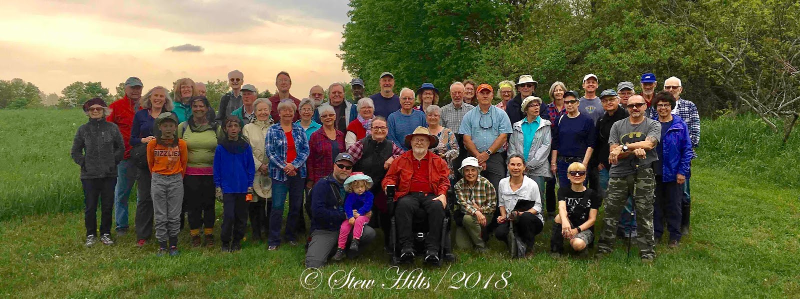
We had a grand gathering in early June to officially open the trail, with speeches that were far too long, but it was a memorable occasion for Maria and I, with many of my Bruce Trail friends.

 The gang at the official opening.
(Stew, Maria and his sister Marilyn centre front)

The main trail through Cuckoo Valley Overlook runs from the Johnson’s Sideroad parking lot (km. 70.1) east and then south into the forest along the western slope of the valley.  The forest extends south to the waterfall and the stream that feeds it, but you only get a limited view of the falls disappearing over the lip of the rock.  The trail then turns uphill and follows the stream for a short distance before turning south again and heading up to the crest of a hill.  This is the ‘overlook’, and the view is spectacular.

Looking east to Cuckoo Valley

Cuckoo Valley is the narrow cliff-bound valley rimmed with cedars below Eugenia Falls, showing up in the photo as a dark valley on the upper right horizon.

The new side trail leaves the main trail while you’re still in the forested section, and dips east, further downhill, before turning south again.  Marked by the usual blue side trail sign and blazes, it takes you through the woods to the base of the waterfall.

Stew’s sister Marilyn and the new side trail sign.

Through the Woods 

 The waterfall itself is small, but it drops about 30 feet over first the Manitoulin dolostone, and then the Queenston Shale.  Erosion of the softer Queenston Shale under the very hard dolostone is what has created the waterfall.  You can clearly see first the blue-gray and then the red of the Queenston Shale.  For those of you who know it, this is geologically identical, although with less water, to Webwood Falls.


The Falls

Adding this new side trail makes much more use of the large Cuckoo Valley Overlook property, and adds some extra interest for hikers.  It also makes a shorter hike if you don’t want to go uphill all the way to the overlook!

The idea for this side trail was floated several years ago by Cathy Little, the Land Steward then, and myself.  In fact the first time I found my way down to below the falls, I had snowshoed in during the winter.  The falls I found was a spectacular sheet of ice!  The slopes beside the waterfall are impossibly steep, as you can see below, so the plan is to build a viewing platform from which to view the falls, as soon as funding can be found.


The trail through Cuckoo Valley Overlook is great at any season, and with both the crest of the hill and the waterfall as destinations, it’s a great hike.  The main trail among those trees on the upper right of this photo skirts the waterfall, but with no view of the falls, you don’t even realize that this is down below you.  Now there’s a way to get down and see it.  Hope you get to enjoy the new side trail sometime.

Photo Credits to Marilyn Hilts, Ned Morgan and Stew Hilts
Transferred this from a Word file, so there may be some spacing issues.

Sunday, August 18, 2019

Misty Meadows Market

Misty Meadows Market was fabulous!  We first stopped when it was a small roadside stand.  It grew to a small store inside a house where we stopped many times.  Over the years it added an outdoor veggie stand in season, and a small chip stand.  Now it's this huge modern grocery store.  We were very impressed.

Easy disabled parking right up front.

And lots of fresh things out front, from cut flowers to a long veggie stand.

This is a great place to get bulk veggies like small cukes for making pickles.  We were there for peaches for making jam.

A transport truck was there unloading a few things (probably from the Mennonite run Bruce-Huron Produce Auction near Lucknow).  This dog looked out from the front seat.

Inside the store was bright, roomy and clean.

The Mennonite-made quilts on the upper walls were striking, and all remarkably cheap, less than $1000.00.  That's probably a good deal less than $10.00 an hour!

There were more kinds of honey than I've ever seen, and lots of baking, including of course butter tarts.

Mennonites don't play a lot of musical instruments, though some churches are known for their beautiful four-part acapella singing.  But they obviously play the harmonica.  There were two shelves of these, at prices up to $400.00.  The straw hats always appeal to me.

Even the checkout counter was beautiful, polished wood made by a local carpenter.

We said good-bye to the horse and headed home with our peaches.

*****

A Note on the Mennonite Culture

I'm not Mennonite, but I sense that there is a lot of local misunderstanding of the Mennonite culture because Mennonites do tend to form a community unto themselves, with their own churches and schools.  We also tend to base our judgements on seeing 'horse and buggy' Mennonites, while actually these Old Order Mennonites (or possibly Amish) represent only 10-20% of Mennonites in the community.

Mennonite churches believe strongly in the importance of family and local community, usually associated with a particular local church.  Decisions are made locally and thus over time tremendous variation evolves compared to mainstream churches, from very traditional and conservative to quite modern.  Many Mennonites would be indistinguishable from you or I in appearance, though their personal commitment to living a life of peace and love might be different (and admirable).

Thus you can't tell a Mennonite by whether they have electricity on the farm, whether they use tractors, or whether they drive modern cars.  There are an increasing number of Mennonites in Grey County, and I'd like tp learn more about their culture.